Will do that as soon as i get home (not on my computer ATM).Komi-Permyak Autonomous Okrug perhaps?
You are using an out of date browser. It may not display this or other websites correctly.
You should upgrade or use an alternative browser.
You should upgrade or use an alternative browser.
Q-Bam Borderpool Improvement and Core Thread
- Thread starter Drex
- Start date
-
- Tags
- map q-bam borderpool
Crazy Boris
Banned
Byzantine Egypt southern border:
View attachment 424133
Medieval Russo-Swedish border and border of Finmark:
View attachment 424132
Permyak-Komi Aut. okrug:
View attachment 424134
Nice to see some more pre-modern stuff in there.
Shouldn't the borderpool include ALL borders that have ever existed, ALL separatist claims and them some?Nice to see some more pre-modern stuff in there.
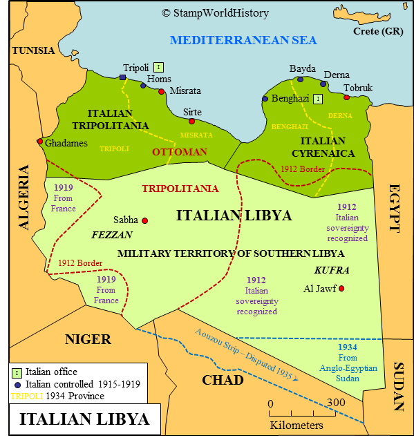
Speaking of which, what about the Azou Strip on maps? Oddly enough, I believe that it is only ever shown as French on maps set after WWII, after Britain had ceded the area to Italy.I have a 1914 map which shows italian libya like that...
Also it seems like mine is the accurate one:
Either way i think its better we keep both on the borderpool.
Crazy Boris
Banned
Will anyone do the old border for Labrador, the one that followed the coast? This is one of the better maps I could find for the southern half of it:
I can give it a try.
Crazy Boris
Banned
Alright, so here's Labrador coast, best as I could manage mostly just eyeballing it from the map

I also did one for the Gibe Kingdoms in Ethiopia

I also did one for the Gibe Kingdoms in Ethiopia
with the power of eyeballing i present my shot at adding the rif republic to borderpool
please do point out any mistakes i might have made https://en.wikipedia.org/wiki/Rif_Republic

please do point out any mistakes i might have made https://en.wikipedia.org/wiki/Rif_Republic
So, I know this was discussed a while back, but, why are there two Libyas? We need to pick one or the other.
And secondly, why is the new Libya extending into Algeria? The Italians only ever ceded two lands to the French: Savoy and Nice.
And secondly, why is the new Libya extending into Algeria? The Italians only ever ceded two lands to the French: Savoy and Nice.
Crazy Boris
Banned
Here's Scotland, with borders for:
-Hadrian's Wall
-Antonine Wall
-Strathclyde
-Galloway
-Moray
-Dal Riata
-Fife
-Caithness/Cait
-Ce
-Fortriu
-Fotla
-Gowrie
Decided to do the rest of the middle east, mostly just to keep myself productive towards the end of the year. I also didn't know what to do with the iraq-saudi border because both get in the way of the other.
Borders include: Regions of Saudi Arabia and Provinces of Iran, Sharifate of Mecca-Yemen Viyalet border, Al-Hasa, Ottoman Empire Arabian Border, Treaty of Sevres borders in Turkey, Spheres of Influence in Persia, the Euphrates and Tigris, Bandar Abbas Leased area, disputes in Rub-al-khali, Uqair Protocol borders, and of course, loads of colors for it. I also kept the Kurdistan borders, just fyi
Azerbaijan will probably need an extra border delineating the Imperial Russian era border of Dagestan (basically the border between European and Asian Azerbaijan).View attachment 426207
Decided to do the rest of the middle east, mostly just to keep myself productive towards the end of the year. I also didn't know what to do with the iraq-saudi border because both get in the way of the other.
Borders include: Regions of Saudi Arabia and Provinces of Iran, Sharifate of Mecca-Yemen Viyalet border, Al-Hasa, Ottoman Empire Arabian Border, Treaty of Sevres borders in Turkey, Spheres of Influence in Persia, the Euphrates and Tigris, Bandar Abbas Leased area, disputes in Rub-al-khali, Uqair Protocol borders, and of course, loads of colors for it. I also kept the Kurdistan borders, just fyi
The borders in Afghanistan are provincial borders. Modern Afghanistan didn’t have any borders I could find within the actual country.The borders in Afghanistan don't make sense, and the northwestern part of OTL Azerbaijan warrants its own coloration as it has at times been part of Georgia.
Somebody has turned the main image into a JPEG and the quality has drastically dropped
No, that's just DeviantArt being stupid, you need to press the "Download" button to open the full image in a new tab
You could have Kunduz, Badakhshan, Bactria/South Turkistan, Nuristan, a Pashai/Gandhara state, an eastern Pashtun polity, a western Pashtun polity, a Hazajat, an Aimaq state, and, perhaps a west Afghan Persian/Khorasan state.The borders in Afghanistan are provincial borders. Modern Afghanistan didn’t have any borders I could find within the actual country.
No, that's just DeviantArt being stupid, you need to press the "Download" button to open the full image in a new tab
Is that for everyone? That trick does not seem to really work for me.
Share: