You are using an out of date browser. It may not display this or other websites correctly.
You should upgrade or use an alternative browser.
You should upgrade or use an alternative browser.
Q-Bam Borderpool Improvement and Core Thread
- Thread starter Drex
- Start date
-
- Tags
- map q-bam borderpool
Southern Africa: Botswana's crownlands and tribal reserves (or could also be considered bantustans), Caprivi Strip color onto the map, Skeleton coast and Etosha National Park as Proposed by Fox Odenaal, Zambezia color + redid Sofala, Orange River (important border between Griqualand West and British Bechuanaland with Cape Colony), Border of the South African Republic (Transvaal) before the Treaty of Vereeniging, Buffalo River (a border between Natal Colony and Zululand before annexation)
Ogaden: Disputed boundaries between Ethiopia and Italy before 1908 which resolved most of the dispute until the Abyssinia Crisis, Small territory given to Italian Eritrea as part of the Franco-Italian Agreement
Darfur: Northern Border of Darfur Sultanate during the Egyptian domination
West Africa: Colors for Fulani, Hausa, and Eastern Nigerian State, Reorganized some of the colors for Northern Nigeria, Added Lagos Colony before it was amalgamated with Southern Nigeria Protectorate, Liberian borders before agreement with the French in 1892 and some that were annexed by the British, borders of Upper Volta in Niger, Border of Senegambia and Niger with Benin, added color for Danish and Dutch gold coasts, and added Kingdom of Dagbon
How did the inaccurate q-bam version of the tordesillas meridian come into existence anyway can someone please explain?I have a huge problem with the tordesilhas meridian:
The outer part of the curve should face west not east.
Five seconds of internet searching led me to this:


I found it in a 1520 historical Q-BAM and just copy-pasted. So it's partially my fault for not checking.How did the inaccurate q-bam version of the tordesillas meridian come into existence anyway can someone please explain?
oh okI found it in a 1520 historical Q-BAM and just copy-pasted. So it's partially my fault for not checking.

I have a 1914 map which shows italian libya like that...But Italian Libya is already there.
Also it seems like mine is the accurate one:
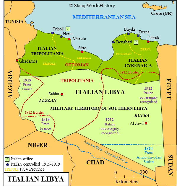
Either way i think its better we keep both on the borderpool.
What in tarnation is a Veyshnoria and why are we putting it on the borderpool?
https://en.m.wikipedia.org/wiki/Veyshnoria
I don't think fictional countries should be on here; the map would get way too crowded.
Veyshnoria is based in truth. (The area called veysnoria has a lot of ethnic poles in it)https://en.m.wikipedia.org/wiki/Veyshnoria
I don't think fictional countries should be on here; the map would get way too crowded.
As great as it sounds to add that in, since it didn't exist previously in history nor was it a proposed border nor was it a disputed border. But idk, considering we are adding Kurdistan, and the only actual defined border it has is the one in Iraq. If we are, we might as well give it its own color, but really only if it's that important.Veyshnoria is based in truth. (The area called veysnoria has a lot of ethnic poles in it)
As great as it sounds to add that in, since it didn't exist previously in history nor was it a proposed border nor was it a disputed border. But idk, considering we are adding Kurdistan, and the only actual defined border it has is the one in Iraq. If we are, we might as well give it its own color, but really only if it's that important.
Why not? it could double for "Discontinuous Polish Vassal/Minor Wends/Veyshnoria"
decided to contribute to this thread again with: divided sakhalin https://en.wikipedia.org/wiki/Sakhalin#Russo-Japanese_rivalry

Komi-Permyak Autonomous Okrug perhaps?European russia mostly done.
View attachment 423989
Share: