Still got an independent Switzerland, though. Damn, that place really is eternal.
Someone: Switzerland, what your thoughts in becoming part of a union of Central-European nations?
Switzerland: Not today Satan, not today!
Still got an independent Switzerland, though. Damn, that place really is eternal.
This is like the early twentieth century equivalent of bad AH maps where space-filling empires take up most of Africa, Asia and Latin America, or the POD is in 1300 but the Russia-Kazakh border is still the same. The Polish Lithuania Commonwealth's eastern border is this map's equivalent of "that damned Kazakh border" trope. Poland's interwar eastern border closely resembled the second partition, but even that territory would only be stable with Ukrainian and Belarusian autonomy similar to OTL Scotland or Catalonia.I really can’t vouch for any map that assumes Britain and Italy should be in the same supranational Union.
Also how is the NE group supposed to even work? It’s just OTL Russia, but unwieldier. “Poland” could really be its own group.
Also the Caucasus deserves its own supranational Union.
Actually, this whole union idea/thing is ASB (especially for the early 20th century) and wouldn’t help anything even if it were implemented.
Or names that end in "-ia"Also in the future the world is covered by space filling empires whose names all start with “The”.
Please tell me this is just very, very loose federations, because I can't imagine how uniting the Balkans together would bring peace.
1945 proposals for border between Poland and RSFSR:
1945 proposals for border between Poland and RSFSR:
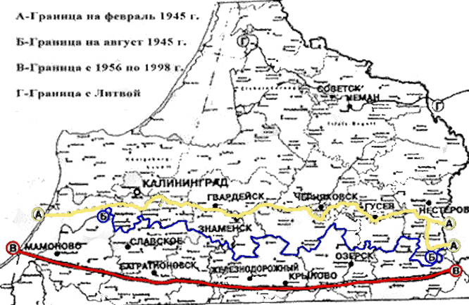
AFAIK, only proposals, and the first one supposedly dates to the Teheran Conference in 1943, that is 2 years earlier than the caption suggests. The second one was a rough draft, and only third one was actually established.Are those proposals or the actual borders in February 1945, August 1945 and then in 1956?
But what about those years then? Why are they mentioned here?AFAIK, only proposals, and the first one supposedly dates to the Teheran Conference in 1943, that is 2 years earlier than the caption suggests. The second one was a rough draft, and only third one was actually established.
I guess the supposed meaning was “borders as agreed at the date …” or something like that.But what about those years then? Why are they mentioned here?

I found this meme, though I'm not sure of the veracity. It's actually a nice shaped border, anyone got a patch for that?
As an Argentinian I can tell you that previous to the Conquest of the Desert and the establishment of official borders in Patagonia, both Chile and Argentina claimed all of it. For logistical reasons, Chile never managed to cross the Andes and settle there. However, it's not uncommon to see Chilean textbooks that show all of Patagonia as being part of Chile.I found this meme, though I'm not sure of the veracity. It's actually a nice shaped border, anyone got a patch for that?
This isn't as much as a proposal but rather something which actually existed for like almost ten years. These are the PRoC's territorial subdivisions in 1949, and they mostly stayed like this until the late 1950s. Provinces and autonomous regions are in blue, territories in pink, separate municipalities in red. Since there are proposals to divide the bigger Chinese provinces even today, this is something one could easily draw inspiration from. Here is a list with all the data on them, including their abolition dates.
I found this meme, though I'm not sure of the veracity. It's actually a nice shaped border, anyone got a patch for that?