zesamofdepast
Banned
This thread will host a series of Europe maps I have created!
Attachments
-
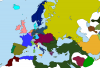
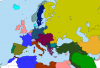
 1830.png145.2 KB · Views: 5,900
 -
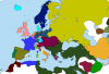
 1848.png111.7 KB · Views: 4,770
 -
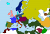
 1859.png110.6 KB · Views: 2,917
 -
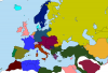
 1861.png109.6 KB · Views: 4,453
 -
 1871.png133.8 KB · Views: 3,041
 -
 1894.png132.3 KB · Views: 5,110
 -
 1914.png130.8 KB · Views: 4,818
 -
 1936.png106 KB · Views: 35,379
 -
 1982.png112 KB · Views: 4,059
 -
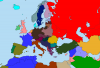
 2018.png116.7 KB · Views: 3,659