You are using an out of date browser. It may not display this or other websites correctly.
You should upgrade or use an alternative browser.
You should upgrade or use an alternative browser.
WIP Map Thread
- Thread starter B-29_Bomber
- Start date
-
- Tags
- work in progress

That sounds like a loaded question.So... you like wanks?
So... you like wanks?
A day on AH.com without somenation getting wanked is like a day without sunshine.
ST15RM
Banned
Uhhh....A day on AH.com without somenation getting wanked is like a day without sunshine.
You don't actually need a legend, is the thing.legend
Isaac Beach
Banned
Working on an entry for the MotF 187, based on some fascinating discussions in Before 1900. Debating if and how to split Texas.
UPDATE: Small update, you may be able to guess the basic concept out of this, and the result.

UPDATE: Small update, you may be able to guess the basic concept out of this, and the result.
Last edited:
Nah, I do not like maps without legend, usually don´t know what is going onYou don't actually need a legend, is the thing.
 Even if this one is pretty obvious...
 And I have a different idea
(thx btw)
Emperor-of-New-Zealand
Kicked
A WIP for the latest iteration of my Leygurian World. It's a map project I redo every couple of years, totally ASB, but the concepts get whackier every time. Usually I have it set in an alt-1914 showing the full extent of European colonisation on the world, but this time I've decided to go back to around 1880 (so the Americas will be filled in, but Africa will still be mostly terra nullis). The golden nation in Southern Europe is the Empire of Leyguria. The basic premise of this nation has always been that a state on the Ligurian coast developed separately from any broader French or Italian identity. In this version, it was basically a Roman remnant following various collapses, but became rich due to the Mediterranean trade routes and more or less survived any overt invasions by migrating tribes.
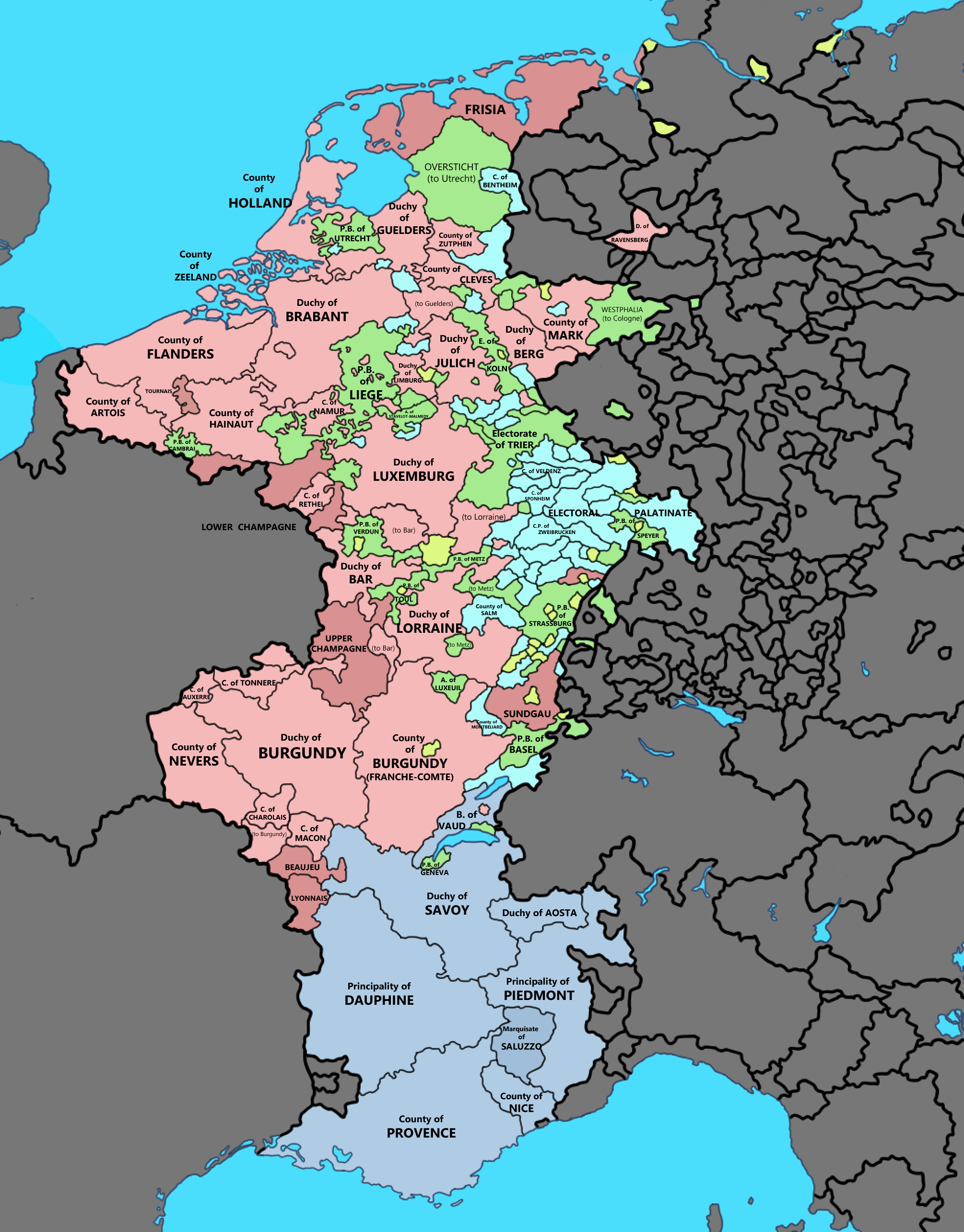
One feature you'll notice is that the Slavs have penetrated far deeper into central Europe, and so the Germans have moved farther west and even south. The two little states north of Greece on the Adriatic Coast are Germanic, as is the Illyrian/Dalmatian section of that big Slavic empire I'm tentatively calling Pannonia until I research a better name. It's a bit like Austria-Hungary, but with the Slavs dominant over a smaller Germanic/Italic sub-kingdom. Northern France is far more German than Latin/Romantic. I considered using the Normandy colour to denote this, but I figured the Belgian/Burgundian colour worked better to denote its unique placement between Germania and the Latin west/south. The grey German nation is currently called the Saxon Confederation, as England is also more German, having avoided any overt Latin influence in the form of the OTL Norman conquest. To the north we see a Celtic Irish/Scottish/Pictish kingdom, with the Norwegians ruling the Isles. I'll probably remove the internal borders of "Poland", because to me it looks too much like a Prusso-Polish union which isn't accurate. It's thoroughly Slavic in culture and language from west to east with very little German presence (though Prussia-proper is likely still quite Baltic). Meanwhile the Baltic nations (Lithuania et al.) have been Slavicised, too.
Also, I wouldn't read too much into the colouring of the Caucasus/Ukraine/Northern Rus; I'm using the Kazakh colour as a reminder to myself that these nations are Turkic and not Slavic. Rather than seeing Cyrillic writing here, we'd see more eastern-influenced writing (though I imagine the Latin alphabet would still have penetrated most of western Europe).
In terms of religion, things are a little nutty. Christianity still arose as an offshoot of Judaism and is definitely the dominant religion in the Mediterranean. There's no Islam, though a monotheistic faith did arise in Arabia where God is referred to as Allah, but it isn't widespread and conflates far more endemic religious quirks than any of the Abrahamic religions. Germanic Paganism is still a strong force in northern Europe, though the Celtic nations are an oddball again as Christianity has penetrated here with some success (though mostly in the ruling classes as a means of trade/alliance). The Slavs still have their own religious traditions as well, as Orthodoxy never split from mainstream Christianity and never spread north. The Turkic nations are all some version of Tengriist (I'm not sure of Buddhism would have still appeared - probably something similar did).
There's a lot more work to be done both in terms of the map itself and the geopolitical situation of the world at large. I intend on repeating the big China-wank of the last version of this map I posted, too, as it's one of my favourite concepts. Basically the goal was to build a world still recognisable, but with far more cultural diversity. In this case, the Christian nations of Europe simply cannot afford to be too picky about their neighbours, because there's enough of a dichotomy that Christianity has no hope of 'conquering' Paganism in the same way it did OTL. Crusades have been lackluster.
The existence of Buddhism would long-predate this POD.(I'm not sure of Buddhism would have still appeared - probably something similar did).
A WIP for the latest iteration of my Leygurian World. It's a map project I redo every couple of years, totally ASB, but the concepts get whackier every time. Usually I have it set in an alt-1914 showing the full extent of European colonisation on the world, but this time I've decided to go back to around 1880 (so the Americas will be filled in, but Africa will still be mostly terra nullis).
Interesting. I look forward to seeing the final result.
Do you still have the previous iterations floating around, and if so, where can I find them?
Emperor-of-New-Zealand
Kicked
Interesting. I look forward to seeing the final result.
Do you still have the previous iterations floating around, and if so, where can I find them?
If you go into the advanced search function and type "Leyguria", and then in the 'posted by member' box put in my username, and limit the search to the Maps and Graphics forum, you'll find a good few of them I think. This version is likely to be very different to all the old versions, of course, except in a few key features.
OTL 1815

Europe is largely complete as a consequence of it being the region with the most detailed and verifiable WorldA representation I could find, though there are key innovations, such as the updated British Isles and the Iberian and Low Saxon coastlines courtesy of @KapiTod, the inclusion on the map of Lake Geneva and the according redrawing of the surrounding area (notably Geneva is a colored pixel in this version), and modified borders in Hanover and Poland.
In North America I've updated the Floridian border in order to connect it better to West Florida/Louisiana. The United States' disputed territories are as of now shown as uncontrolled, save for West Florida and the Mississippi territory coast. They will be filled in if I find a source for one party or another controlling them. Also, I should probably show independent Native American nations, but I haven't yet gotten around to that.
Africa and Southeast Asia are going to be a bitch, because period maps are really poor in those regions and because the non-Westphalian nature of the polities makes it really difficult to define borders or even states.
My Metal Slug TL map again, this time with PODs to have an Axis China and an Allied (Democratic) Japan, and yes the final touches are being put on:

Share: