You are using an out of date browser. It may not display this or other websites correctly.
You should upgrade or use an alternative browser.
You should upgrade or use an alternative browser.
The Q-BAM Improvement and Core Thread
- Thread starter iori
- Start date
Yellow River and Yangtze River don't look right comparing with other Robinson projection map, I'll redraw it, and some province borders accordingly.
(Yangtze River is too north in Hubei province, and Yellow River too north in Qinghai, Henan and Shandong provinces,

and the old version of qbam map I picked up to make no-modern-reservior qbam river map have too fewer lakes on it, and I did't add enough. Here is qbam river map for historical use with more lakes on it.

List of some original map I used:
major rivers mostly picked from Bob Hop's qbam river 3.0 map, (It's the most detailed river map in the qbam soceity, )
lakes mostly from current version of qbam political map,
River Po, Tiber, Odar and some others from ndeignacio's Africa + non-russian Europe river patch, (let me know if this map updated)
US rivers from the US river patch.
and I redrawed the Green River (tribute of Colorado River)
my plan for updating:
redraw Yellow River, Yangtze River, Huai River, add Grand Canel,
(Yangtze River is too north in Hubei province, and Yellow River too north in Qinghai, Henan and Shandong provinces,
and the old version of qbam map I picked up to make no-modern-reservior qbam river map have too fewer lakes on it, and I did't add enough. Here is qbam river map for historical use with more lakes on it.
List of some original map I used:
major rivers mostly picked from Bob Hop's qbam river 3.0 map, (It's the most detailed river map in the qbam soceity, )
lakes mostly from current version of qbam political map,
River Po, Tiber, Odar and some others from ndeignacio's Africa + non-russian Europe river patch, (let me know if this map updated)
US rivers from the US river patch.
and I redrawed the Green River (tribute of Colorado River)
my plan for updating:
redraw Yellow River, Yangtze River, Huai River, add Grand Canel,
Last edited:
Has anyone managed to do a Q-BAM map featuring an accurate outline of the Chad Basin?
WE need a drainage basin Qbam in general.Has anyone managed to do a Q-BAM map featuring an accurate outline of the Chad Basin?
Patched the Baltic coastline from the Danish border to the Finnish border. I'll be moving on to Finland itself in the next couple days. Can't wait to fix Åland, honestly.

I know my patches screw with the existing political borders you guys have worked so hard on. All I can say is I try to make my patches as geographically accurate as possible!
I know my patches screw with the existing political borders you guys have worked so hard on. All I can say is I try to make my patches as geographically accurate as possible!
I redrawed major Chinese rivers and subdivisions, and North Asian rivers, and Hulun lake, Xingkai lake in Northeast China, and moved China major lakes to its right place, except Hongze and Gaoyou lake.
I copy Chinese province border from 8K-bam map by convert it to Robinson projection using G Projector, and then copy it to qbam.

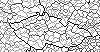
eastern part of robinson version 8k-bam map (I call it 8q-bam) looks like this

I copy Chinese province border from 8K-bam map by convert it to Robinson projection using G Projector, and then copy it to qbam.
eastern part of robinson version 8k-bam map (I call it 8q-bam) looks like this
Last edited:
Hi! Can someone please link me to the latest version of Argentina, with the Buenos Aires partidos?
If this could be transformed into a full blank map including second level subdivisions it'd be awesome.eastern part of robinson version 8k-bam map (I call it 8q-bam) looks like this
There's a river Q-BAM, these could go there so we don't saturate the borderpool with borders than can easily be found elsewhere.The Connecticut River (home of many border disputes in the 1600s and 1700s)
Potentially the Hudson River
Would the river map still be accurate, though?There's a river Q-BAM, these could go there so we don't saturate the borderpool with borders than can easily be found elsewhere.
It hasn't been improved for a long time, so not, at least regarding coastlines. I don't think there's a necessity for it to have perfect coastlines (thought it would be preferable) as rivers can just be cut from it and pasted somwhere else.Would the river map still be accurate, though?
He means qbam border pool thread. I have corrected rivers in China and North Asia, and Tuque corrected United States rivers. and I checked rivers otherwhere, and they don't need much modifing.Would the river map still be accurate, though?
8q-bam map with subdivision looks like this. I cut the map into two pieces (with piece-together overlaps) to fit image size limit. Some area are not readable because 2nd level borders and small lakes crumbled together.If this could be transformed into a full blank map including second level subdivisions it'd be awesome.
Note:
Coastline and national borders in Africa agreed nearly perfectly well, but Coastline and national border in East Asia and North Asia miss by some 2 or 3 degrees due to projection convertion and other round ups add up, the more near the four corners the more disagreement.
Last edited:
Could I get a q-bam map, showing the Mackenzie River Watershed, as well as the Rio Grande, San Antonio, Guadalupe, Brazos and both Colorado Rivers' (Texas, US/Mexico) watersheds?
Edit: And the Continental Divide if possible; I would really appreciate that.
Edit: And the Continental Divide if possible; I would really appreciate that.
Last edited:
Share: