The People's Socialist Atlas

Its sad to see a great member like you leaving. I must say that what you were making is very impressive. When I saw that world map and see in OTL Indonesia city such as Makassar using her former name "Ujungpandang", I realize how detailed your maps are.

But, if you want to make small changes, I think I want to give some minor suggestion:
1. "Melayunesia" sounds neat, and I like that. But I think the term "Indonesia" is already become popular by the 1920s, so if there's a major state in the former Dutch East Indies, I think it will still be named Indonesia (I can see that south Maluku and New Guinea managed to stay Independent from this Melayunesia, tho. Its really interesting.)
2. it seems Melayunesia use OTL modern spelling based on how the cities are spelled, except for Djajakarta, which is in OTL old spelling. If you want to use the old spelling, you could change city like "Ujungpandang" and "Tanjungkarang" to "Udjungpandang" and "Tandjungkarang". If you want to use the modern spelling, you could change "Djajakarta" to "Jayakarta".

Merry Christmas!
 
Last edited:
It's indeed a tragedy that this great work of yours is probably going to be your last contribution to AHdotcom. :pensive:

And it's an even bigger tragedy that the only contribution I can make to this thread is signalling that I seem to have a problem in the second section of the Atlas (AND in the integral book), where pagg. 104 and 105 cannot be enlarged. Am I the only one who has found this problem so far?
 
Great job on this project... it was a true masterpiece! Sorry to see you go, but when you feel it's time to move on, that's what you've gotta do... So long, and I wish you good luck on whatever you do in the future!
 
Very interesting work!
I'm interested in how Northwest Australia became a Jewish state. Did the Zionist Congress decide on it over Palestine? Or did they try to settle in Palestine but the Arabs expelled them? I notice there's no mention of Jews in the section on the Ottoman Empire's collapse, which makes the appearance of "Telbib-Yafa" odd--Tel Aviv was founded by Zionists in 1909, and is not named after any Arabic placename. The use of "Palestinian" is somewhat anachronistic as well, since OTL the adoption of that as an ethnonational identity was in response to Jewish immigration (and it didn't refer solely to Arabs until after 1948). Arabs living there mainly identified as South Syrians.

Also, what's the story behind independent Thessaloniki (which I assume from the religion map is also majority Jewish)?
 
Hey, sorry to make this thread active again, but I have some news! Over the last few months, I've been working diligently to create a version of the Atlas that can be published and bought in paperback. In December, we finished the first draft of the Atlas, which is what went up online at https://sites.google.com/site/peoplessocialistatlas/. But that won't be the version that goes out for print later this year. There's still so much work left to be done! Obviously, there's the editing, but since I'm a huge perfectionist I also want to add a lot more substance to the book. By the time the print version comes out, it might be twice the size of the book you see at the website above. It's going to cover the entire world, every little nook and cranny, and it's going to be fantastic. I'll be dropping previews of some of the awesome maps I've made for the print version over the next few months, until it's ready for ordering. :) So watch this thread for news and updates!

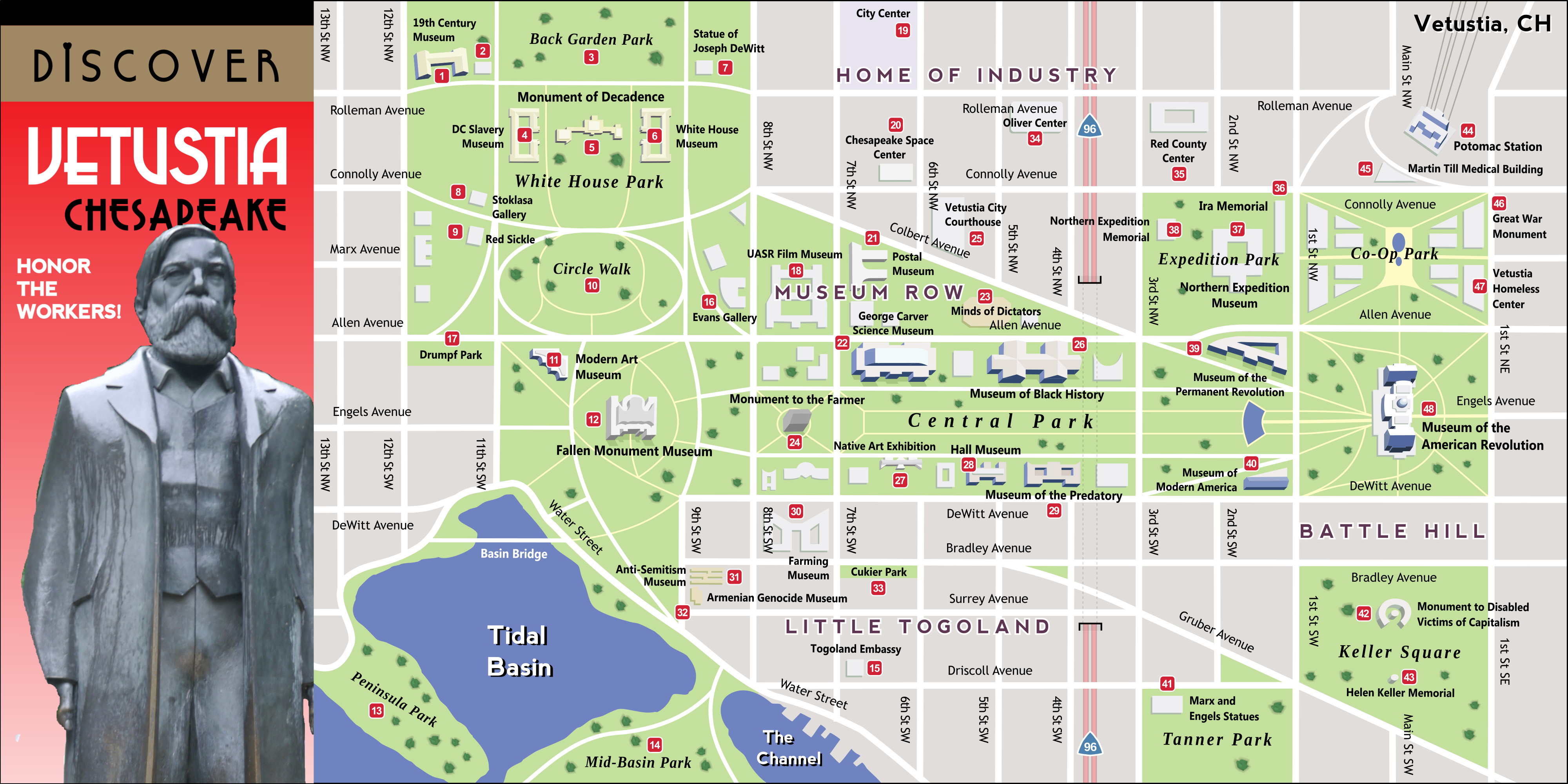
Here's the first new map you'll see in the print version. More updates will trickle in over time. Enjoy! And feel free to suggest things you'd like to read more about, it might very well get more focus!

Vetustia: The Place Imperialism Perished


vetustia__the_place_imperialism_perished_by_upvoteanthology-dcer5iy.png

The map above is Washington D.C. under the rule of the United American Socialist Republics. The city was renamed Vetustia, Latin for "antiquated", and is full of propaganda. The American historical revisionists are in full force here in Vetustia, as all elements of American prosperity before the Revolution have been cleared. The UASR as a whole is actually a pretty fine place to live, and quite democratic. However, some vestiges of the old dictatorial communist regime remain, and there is no place it remains as heavily as it does in Vetustia.
 
The map above is Washington D.C. under the rule of the United American Socialist Republics. The city was renamed Vetustia, Latin for "antiquated", and is full of propaganda. The American historical revisionists are in full force here in Vetustia, as all elements of American prosperity before the Revolution have been cleared. The UASR as a whole is actually a pretty fine place to live, and quite democratic. However, some vestiges of the old dictatorial communist regime remain, and there is no place it remains as heavily as it does in Vetustia.
Does the Stoklasa Gallery show films?
 
There is a distinct possibility of that, considering I’ve already made three maps of Europe in the 20th century, and plan to make more! Any specific regions you’d like to see?

Russia, if possible. I'd like to see a map of the UESR before the Russian Liberation.

And the development of Leithania after the Austro-Hungarian civil war.

Thanks. I'm declaring you officially awesome in advance. :cool:
 
Just want to pop and say that the scope of this work amazes me, and that the only thing that's kept from binging the web version is knowing that there will be an even more amazing printed version. I'll definitely be getting a copy, if only to support all your hard work in some way or another!

When it comes to possible additions to the atlas, I have but one suggestion, albeit a bit of a big one. I find that alternate histories, particularly those that center around maps or 20th century history, have a tendency to overemphasise the role of state actors. Now, I'm not saying this as any sort of accusation; states are clearly of the utmost relevance to cartography and 20th century history both. Nevertheless, it'd be neat to have some segments on non-state organizations, be they global corporations, inter-state organizations such as the UN or the EU, or even anarchist collectives. I imagine that a democratic socialist state like the UASR would be filled with all sorts of experimental communes or worker federations, both state-sanctioned and otherwise. It is your story of course, and non-state actors are harder to put on the map (I'm thinking of some of the later Malê Rising maps), so it makes sense if these sorts of things are left out of the picture. Whatever the case, I can't wait to see what the final version will look like!
 
Hilo, Hawaii

Hey, it's me, back from Nepal! I've spent the last few days working diligently on finishing all the maps necessary to complete the published version of the Atlas. Which, uh, means more teasers for the final version! Gotta get that non-existant hype train rolling so people actually buy it when it releases. Right now I'm hoping for an October release, but you never know with these things. Keep an eye out!

Today's map is of Hilo, Hawaii. In the Atlas-verse, Hawaii was taken as a British protectorate after its independence from the USA, and Hilo was absorbed directly into the British Empire. It basically became the Pacific Hong Kong, growing to 400,000 strong. By the time it was returned back to Hawaii in 2001, it was one of the largest tourism spots in the world. The map below shows a tourist map enticing people to explore old downtown Hilo, which was relatively untouched by the speedy growth of the city. Enjoy!

QywMecX.png

Also, the Atlas has a Discord chat now, if you want updates (and new, exclusive maps from the future book!).
 
Amazing maps! I'm currently sitting...I guess kind of directly in the center of one of the new DC super-blocks and it's kinda freaking me out that the street outside the window is gone ITTL!

Also I'm lucky to spend a lot of time in Hilo and can't wait to find out what those new buildings are!
 
Top