Return of Horrible Educational Maps

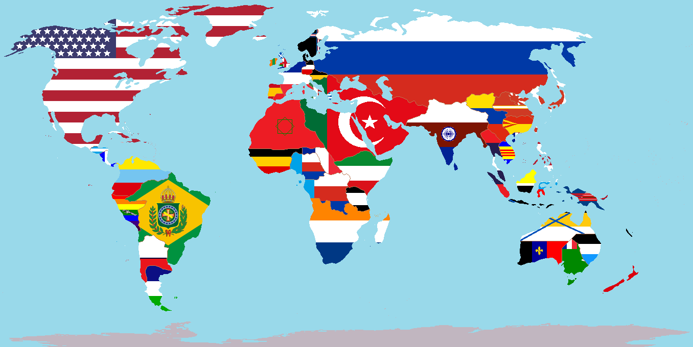
Also, does anyone know what is up with the random green areas?

EDIT: I think that they might be colonies of Brazil, but what's up with the ones in Europe? Especially the one with the "super-realistic" border with Turkey

I don't think any of the "random" green areas are (a) random, or (b) Brazilian.

I think the green strip next to the Turkish flag is part of an alternate Turkish flag.

Then the bit in the horn of Africa is (IMO) part of whatever the horizontal tricolour country is.
 
It's from the timeline "A World of Difference" on the Althistory Wiki.

latest
I was fixing to say, this is someone's fetish.
 
"Hey you ever think about how the division between Europe and Asia is kind of arbitrary?"

"Dude where is this coming from."

"I'm just thinking about where to put the border between the two on this map."

"You don't get paid enough to think, asshole, just put it wherever."
 
289082


I am not sure if someone posted this already, but I might as well post it here.

I will now look and find everything wrong with this map. Whenever I find a mistake I will mark a "sin" just like CinemaSins does on YouTube. Once I am done it will be rated on how bad it is.

Lets begin shall we!

Guyanas have their modern borders then they shouldn't!

1

Brazil is still using it border based on the Treaty of Tordesillas, which at this point in the 18th century it pretty much no longer being used.

2

New France has the borders of the US before it had it's Manifest Destiny past the Mississippi!

3

New France lacks Quebec and Louisiana,
this is the 18th century so it obvious that it has to include it. (Unless this map specifically is showing the aftermath of the Seven Years War then still it very wrong on plenty of levels!)

4

What the fuck is going on in the Pacific Northwest? Did the maker of the map really did not give shit about the borders of British claimed Oregon? Plus they didn't even owned any of it since it was still being explored.

5

New Spain stretching up to the Pacific Northwest (including parts of coastal British Columbia). As well as New Spain having the modern day US-Canadian border.

6

Portugal still having the claims in Africa. Seriously Ghana and Sierra Leone are landlocked.

7

Even though the map maker sort've got the location of Dutch South Africa correct, he still fucked up by having Britain owning much of it as well during this time.

8

British have the 20th century borders in Africa. Seriously you can see Rhodesia, Sudan, Kenya and Tanzania. This is so cancerous.

9

Poland-Lithuania lacks Lithuania... It only has Belarus, so it would be pretty much called Poland-Belarus. Which never even existed!

10

France has it 20th century territory in Africa...

11

Why does the Ottoman Empire claim all of Ukraine?

12

The British own part of the Middle East in the 18th century...

13

Spain owns much of Italy, why is that?

14

Spain has Western Sahara...

15

Germany should be Holy Roman Empire, but still the borders are way beyond wrong.

16

French didn't colonize Indonesia yet, and plus where is the Kingdom of Siam!?

17

Where is the Ming Dynasty? This is the 18th century, so where are it's borders!?

18

Modern day Kazakhstan border... This gave my cancer literally cancer.

19

Portugal never colonized Somalia or Djibouti let alone any European nation colonizing the Horn of Africa during this time.

20

Britain didn't have all of India in 18th century!

21

Why does the modern day border of Indonesia and Papua New Guinea exist!?

22

Why does the Netherlands own Denmark??????

23

Denmark has Greenland but lacks Denmark

24

Also it is called the Netherlands!! Not "Holland" get it fucking right.

25

France has it modern day borders, when it should have it borders excluding Savoy (which is why France looks like it is today since it took Savoy)

26

Spanish Corsica never existed, though I will admit the name sounds interesting...

27

Spain owns all the Lesser Antilles.

28

Why are the Thirteen Colonies simply just called New York? Did New York got wanked!??

29

Britain owns Cyprus which they never did until after World War I, from what I remember in history.

30

Portuguese Hainan

31

Portuguese Taiwan

32

British Malaysia existing in the 18th century...

33

Why is Lebanon independent?

34

Russian Alaska has the modern day borders of the US state of Alaska...

35


Portuguese New Caledonia

36

Portuguese Vanatu

37

Mozambique has it modern day borders when it shouldn't...

38

Independent Lithuania when it should be apart of the Polish-Lithuanian Commonwealth

39

Congo has it modern day borders...

40

Not a single bloody African tribal state or kingdom shown on the map. This map is probably only focusing on Asia and Europe.

41

Antarctica was done by hand in MSPaint that it's peninsula looks like some you find out of Japanese tentacle hentai

42

South China Sea is located in the wrong place

44

New Granada is spelled wrong as "New Grenade" wtf?

45

Central Asia and Iran are in grey which makes me confused, this part of world on this map shouldn't be paid attention to or is it just a nuclear wasteland???

46

Conclusion...

THIS GAVE MY CANCER LITERALLY MORE CANCER!
 
"Hey you ever think about how the division between Europe and Asia is kind of arbitrary?"
Could we also mention Far Eastern Siberia?

"Dude where is this coming from."

"I'm just thinking about where to put the border between the two on this map."

"You don't get paid enough to think, asshole, just put it wherever."
Could we also mention Far East Siberia’s weird ass shape?
 
I assume this is a representation of the continents judging by the clipped text?
In which case there are only 2 issues of "horribility": 1) definition of continent, 2) the distorted projection
Even so, missing out the whole Aegean/Anatolia area makes Europe look a bit weird and why label only four countries (Canada, USA, Mexico and Australia - with the last looking like the name of a continent!)?
 
Even so, missing out the whole Aegean/Anatolia area makes Europe look a bit weird and why label only four countries (Canada, USA, Mexico and Australia - with the last looking like the name of a continent!)?
To answer the first it looks like a fill error has eliminated the Black Sea and Aegean. To the second the labelling of the North American countries suggest it's a NA map putting the NA continent into a global context, presumably the previous page was on NA by itself; note that the country names are in lower case and that Australia being the name of a continent is plausible.

I think we need @Mikeduke324 to post the FULL image rather than the cropped one to get a better context!
 
View attachment 387489
From our homework planners in school. Has God forsaken us?

For some reason, that specific distorted world map seems to be a rather popular basemap, just compare the eastern med and Kamchatka peninsula on that one (or basically the entire map)

I'm currently training to be a history teacher, and wandering around in the department files, I found this; the worst thing I've ever seen. The other teacher was dismayed at my disgust, crying "Well I didn't make it!"

Picture1.png

I despair for the education of the youth of Britain.

Of course that this misshapen world map keeps popping up makes it even more horribly educational.
 
for fuck's sake, this is at least the third time that this map has been posted here.

IT'S NOT AN EDUCATIONAL MAP. IT'S FROM PIRATES OF THE CARIBBEAN.

>That moment when the Pirates of the Caribbean themselves might be one of the most boring stories in the actual world of Pirates of the Caribbean. I for one think that Settlers of the Formerly Persian Void would be a much more entertaining movie.

Plot: A multinational group of Ottoman explorers have to work out their differences on the road to the Lost Mountain City of Tehran as they fight against the environment, their ethnic differences, and all while being pursued by the vengeful Angra Mainyu and a bloodthirsty British conquistador and claimant to the British throne who will stop at nothing before seizing the power of Zurvan to bend the earth to his will.
 
Top