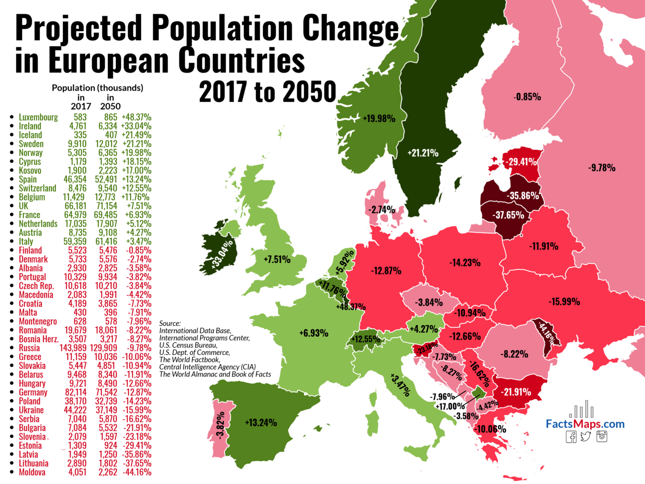
OTL Map Thread Mk IV., 2014-

Finland at least holds its own. Lithuania, Latvia and Moldova get flattened.
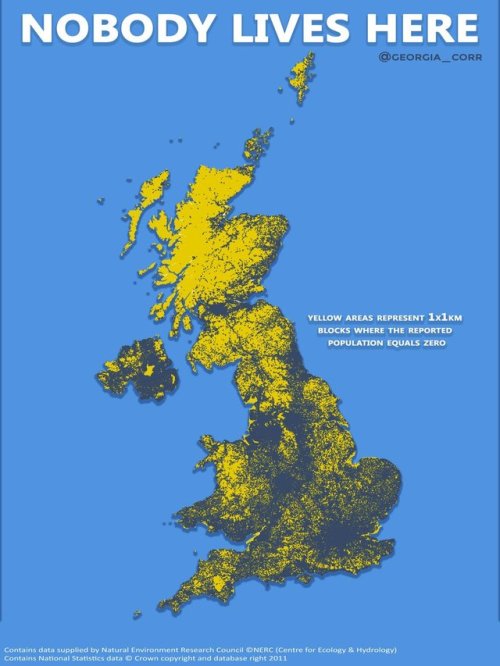
I was thinking about this, maybe with the Moldovans its about the situation their country is, and my bet is they are fleeing to Romania. As to the other two my guess economics and Russia might have something to do with it.
 
Low birthrate + chronic population drain (because of economics and "greener pastures") = pictured in Lithuania/Latvia. I would suspect the only reason similar countries like, say, Poland is doing much better is because of a higher birthrate and a better economy. The Great Plains states in the US are suffering a similar problem, and the Deep South on a smaller scale.
 
Here is an OTL map I made of Canada's 2015 federal election by riding. Map created with QGIS and data provided by the Government of Canada and scale used is a slightly modified scale from US Election Atlas.

3Cn4EdRq_o.png
 
So it seems the technique I came up with for working on Mercator's map is passably adequate for almost any map projection.

Source: http://www.hipkiss.org/data/maps/lo...e-balcan-states-and-rumania_3012_3992_600.jpg

Deviantart: https://ashtagon.deviantart.com/art/The-Balkan-States-and-Rumania-1920-730745866

States

Kingdom of Bulgaria (https://en.wikipedia.org/wiki/Kingdom_of_Bulgaria)
Kingdom of Greece (https://en.wikipedia.org/wiki/Kingdom_of_Greece)
Kingdom of Romania (https://en.wikipedia.org/wiki/Kingdom_of_Romania)
Kingdom of Yugoslavia (https://en.wikipedia.org/wiki/Kingdom_of_Yugoslavia)
Occupied Constantinople (https://en.wikipedia.org/wiki/Occupation_of_Constantinople)
Occupied Smyrna (https://en.wikipedia.org/wiki/Occupation_of_Smyrna)
Ankara Government (https://en.wikipedia.org/wiki/Government_of_the_Grand_National_Assembly)

Important Events

Treaty of Neuilly-sur-Seine (https://en.wikipedia.org/wiki/Treaty_of_Neuilly-sur-Seine): Western Thrace taken from Bulgaria and given to the Entente as a mandate in November 1919.
San Remo conference (https://en.wikipedia.org/wiki/San_Remo_conference): Western Thrace given to Greece in April 1920.
Treaty of Sèvres (https://en.wikipedia.org/wiki/Treaty_of_Sèvres): Occupied Constantinople given to Turkey in August 1920.

Observations

The territory of Greece in Anatolia doesn't match up with other maps showing Greek territory awarded in the Treaty of Sèvres. The best indication of the Greek-Turkish borders appears on (https://en.wikipedia.org/wiki/File:Greco_Turkish_War_1919-1922.svg) and (https://en.wikipedia.org/wiki/File:Frontsturkishwarofindependence.jpg).

the_balkan_states_and_rumania_1920_by_ashtagon-dc32f4a.png
 
Last edited:
c

your-instructions-from-moscow:

TERMS OF SURRENDER

VIETNAM is to be partitioned provisionally at the 17th parallel, the north portion (pop. 12 million) to go to the Communists. Cambodia is to be cleared of all guerrillas and left free to deal with its local Communist problem as it can.

Laos, though remaining independent like Cambodia, must set aside two enclaves in the north for “indigenous” Communists, who presumably will remain armed and active. Both Laos and Cambodia are apparently permitted to build up their armed forces for defense, with foreign help if they wish, and both may call for foreign military assistance if they think their security is threatened. They can belong to a military alliance if it is not in violation of the U.N. charter.

TIME, 2 August 1954

The Geneva Accords, signed in July 1954, brought an end to the First Indochina War. France withdrew from Vietnam, and the country was split between a Viet Minh-controlled north and a French-backed regime in the south, to be united after free national elections. These elections were never held, and Vietnam remained divided until the fall of South Vietnam to Communist forces in 1975.


If the Earth’s rotation slowed down and finally stopped, the massive oceanic water migration would cease and sea level would be at different locations, completely changing world geography.

The extent of a hypothetical northern circumpolar ocean over the territory of North America is shown. The orange color indicates areas with elevation higher than 3,000 meters above the level of the northern ocean. Red dots represent some of the biggest cities of the continent.

(Source: esri.com)


The world in 2100 split into 11 equal areas of population, according to UN medium fertility estimates.

(Source: reddit.com)


If the Earth’s rotation slowed down and finally stopped, the massive oceanic water migration would cease and sea level would be at different locations, completely changing world geography.

The extent of a hypothetical northern circumpolar ocean over the territory of North America is shown. The orange color indicates areas with elevation higher than 3,000 meters above the level of the northern ocean. Red dots represent some of the biggest cities of the continent.
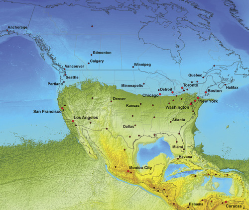
Well, at least Chicago will finally be on the North Coast.
 
Top