And that is one. Big. Armenia.
And, remember, that's roughly half of the territory that the Armenians claimed (and one chunk of that was supposed to be set aside for the Pontic Republic, but they felt it was too small to survive.
And that is one. Big. Armenia.
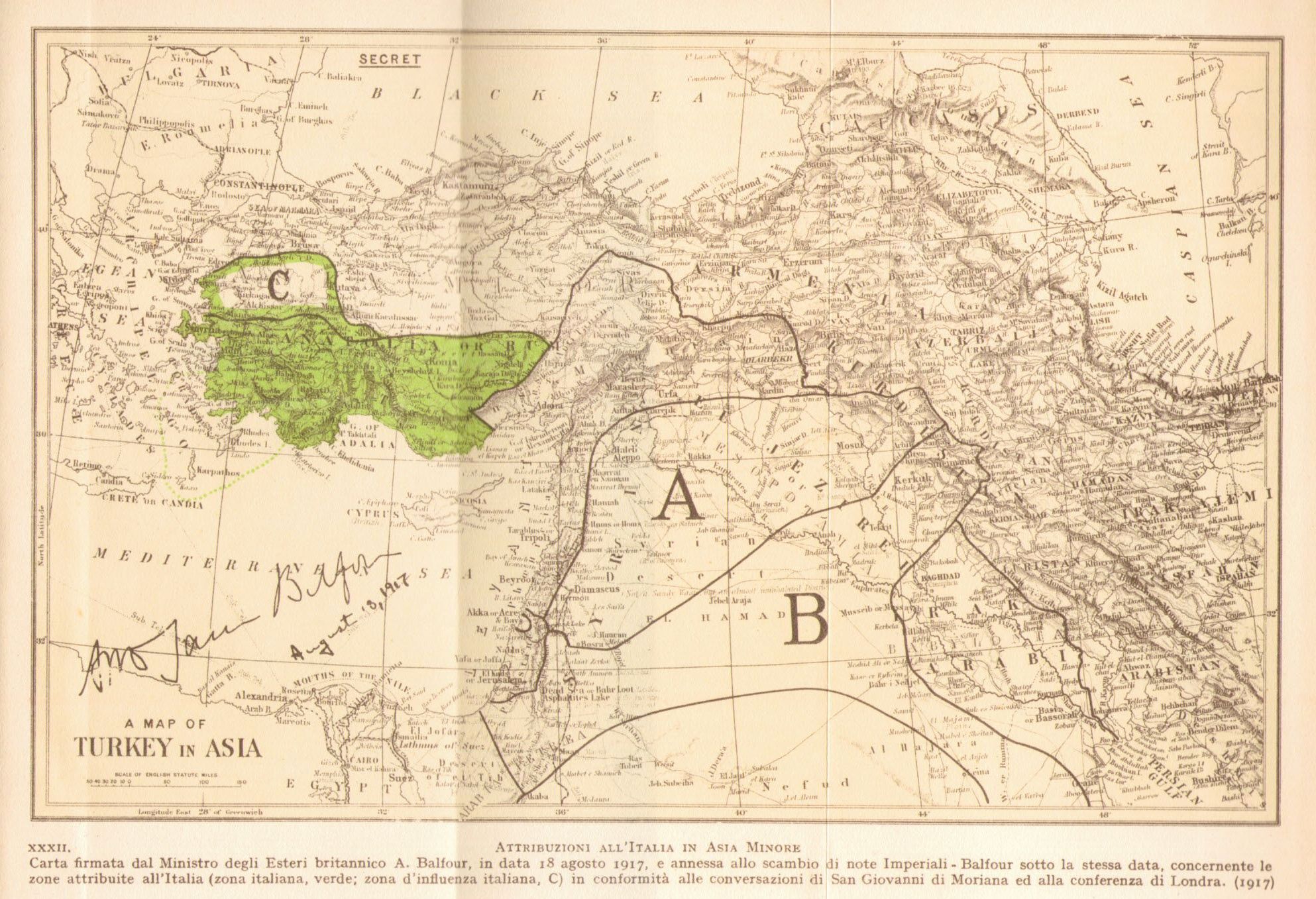
There is something strangely satisfying about straight borders, at least until the sectarian conflicts start. Though ironically enough that Arabian border you mention was actually strictly provisional; it was intended to be redrawn once the UK worked out the tribal boundaries there, and the British government at least claimed they could have handed over that entire area to some united Arab state.That... is a strange, strange treaty. I didn't really appreciate its strangeness until it was all spelled out. Why on Earth did anyone involved think Turkey would accept this? And that is one. Big. Armenia. Gotta say, though, the divisions in the rest of the Middle East are strangely pleasing to the eye, in a sleek, minimalist, ergonomic, horribly colonialist sense. The way that curve in Arabia matches with the straight line in Mesopotamia... yummy. Also, the independent Hejaz makes me squee. But yeah, talk about a rough deal for Turkey.
I don't know exactly what the demographic situation was, but I have a feeling that at that time Aleppo may have had a Turkish majority and the Zor Sanjak was probably included more for territorial cohesiveness than a reflection of ethnic boundaries. As for the Mosul vilayet, there's no way in hell the Turks were going to willingly give it up, Arabs and Kurds be damned.The Misak-i Milli proposal, on the other hand, seems a bit off on what it considers "Turkish." There are some lands included that aren't even in that darker shade, that even then were decidedly not Turkish. Both of these, I guess, just go to show how unrealistic and hair-brained some map propositions were in history. And still are today, looking at the Middle East.
Thanks very much!Wonderful work, man, just wonderful work.
The absurdly huge Armenia you're thinking of was just a proposal at the Paris Peace Conference, while the territory shown in the maps above is the actual territorial claims of the Democratic Republic of Armenia. Though, to be fair, I bet there were some Armenian politicians who didn't give up on the Paris Peace Conference idea, at least until they were killed by the Soviets.And, remember, that's roughly half of the territory that the Armenians claimed (and one chunk of that was supposed to be set aside for the Pontic Republic, but they felt it was too small to survive.
That... is a strange, strange treaty. I didn't really appreciate its strangeness until it was all spelled out. Why on Earth did anyone involved think Turkey would accept this? And that is one. Big. Armenia. Gotta say, though, the divisions in the rest of the Middle East are strangely pleasing to the eye, in a sleek, minimalist, ergonomic, horribly colonialist sense. The way that curve in Arabia matches with the straight line in Mesopotamia... yummy. Also, the independent Hejaz makes me squee. But yeah, talk about a rough deal for Turkey.
The Misak-i Milli proposal, on the other hand, seems a bit off on what it considers "Turkish." There are some lands included that aren't even in that darker shade, that even then were decidedly not Turkish. Both of these, I guess, just go to show how unrealistic and hair-brained some map propositions were in history. And still are today, looking at the Middle East.
Wonderful work, man, just wonderful work.

So, the Arab Shia State has PLENTY of Sunnis, Kurdistan is yuuuuuuge, Baluchistan(?) is independent for some reason. The West Bank (one of the main reasons you would draw a map like this) is still "status undefined," and the Saudis are relegated to a rump state whose acronym in English is S.H.I.T. Among other things, of course.I feel like this would be as good a time as any to post this infamous map.
So, the Arab Shia State has PLENTY of Sunnis, Kurdistan is yuuuuuuge, Baluchistan(?) is independent for some reason. The West Bank (one of the main reasons you would draw a map like this) is still "status undefined," and the Saudis are relegated to a rump state whose acronym in English is S.H.I.T. Among other things, of course.

Also of course the acronyms for the Arab Shia State and the Saudi Homelands Independent Territories would be ASS and SHIT respectively, so... I don't think this map ever was a serious suggestion.
So, what’s the story behind this map anyways?I feel like this would be as good a time as any to post this infamous map.
I feel like, for the benefit of anyone who doesn't already know, pointing out that this map is almost certainly a joke.I feel like this would be as good a time as any to post this infamous map.
I feel like, for the benefit of anyone who doesn't already know, pointing out that this map is almost certainly a joke.
Actually, there is already a version of this map on Q-BAM, outdated as it may look.I feel like this would be as good a time as any to post this infamous map.
WorldA versionWhat I would like to see, though, is a map of the King-Crane Commission.

Serious question re: Megali Idea.
The Greek aims in terms of zones of control were always pretty much the Aegean coastline and nothing else inland for Anatolia, right? I always took it they essentially wanted the Greek-settled lands of the Turkish Aegean coast, pre-Alexander the Great/Hellenistic Age (from Doris-in-Asia northwards to and including the Straits Zone).
I think so yes, it's basically some sort of vague idea that the ancient Ionian cities of the Anatolian coast meant that the population along that strip was 'ancestrally Greek' whereas the interior was not.
That makes sense, thank you. I always found it fascinating Classical Greece's primary geographical area where The Greek People lived - not a mere city-state or colony but "Greece" as a contiguous area - was vaguely equivalent to ethnic maps where Greeks lived in in the 19th and early 20th centuries.