Map Thread XVII

Status
Not open for further replies.
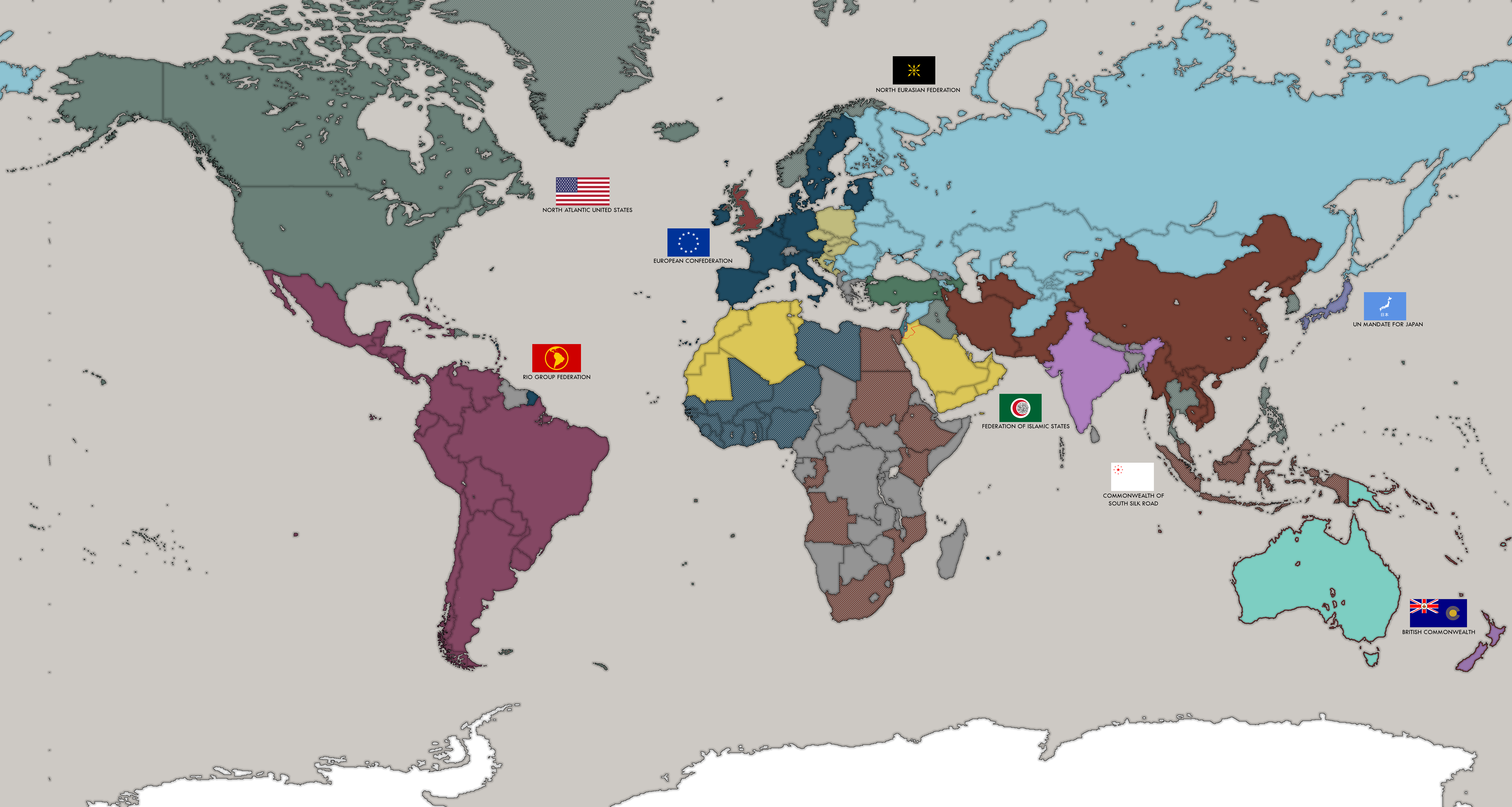
So, this is map of Earth in my sci-fi universe. It's map before a start of second space race. Feel free to ask a questions
"2070. Seven decades of catastrophes and wars were reflected in the largest war in Southeast Asia and Oceania, the worst of which was only the Second World War. India, Indonesia, the Philippines and the northern coast of Australia were burned by the fire of tactical nuclear strikes, and weakened countries were torn by the powerful predators of this world.
In the Middle East, after the extinction of ISIS, a conflict erupted in Jordan, the wreath of which is the Israeli-Saudi war, when the largest oil fields of the League of Arab States were flashed in just a week. The surge in oil prices has led to an acceleration of integration processes in South America and the CIS, while NATO has experienced a crisis and decline, retreating to nationalist governments in Europe.
The global crisis was shaking the world, lying under the shadow of the Chinese dragon, who struck at the right moment. Economic and political expansion led to the creation of a gigantic Asiatic-African bloc stretching from South Africa to the DPRK.
At this time, the eternal enemy of the Chinese fell under the onslaught of international forces. Japan rebelled against its transatlantic hosts, deciding that the Sun had to rise again. The right-wing nationalist cabinet abolished post-war agreements to reduce the army, secret nuclear weapons were also secretly developed. The result was unsuccessful - Japan was torn between the UN forces under the leadership of the United States and the North-Eurasian Federation.
The experience of the Asian War of the 2060s to counter missile launches from space spurred the world's superpower to a new space race, which scientists used to guide a dangerous arms race toward the way of saving Mankind - to the exploration of the space.
The world entered the seventh decade, into a dark and uncertain future."

2_by_kreiviskai-dbq9166.png

Dang, seem like Earth is going to blow itself Fallout style real soon.
 

kreiviskai

Banned
Dang, seem like Earth is going to blow itself Fallout style real soon.
Well, I would not say so. Of course, the burned Middle East and Philippine oil fields will hit the world economy, on the background of the ruined Asia the resource colossuses of Latin America and Eurasia are rising.
In the end, there is still the Tunguska basin, not even fully explored
Oil will last long.
(google translate, im not a well english speaker)
 
Last edited:
Here's the worlda for 1824, I didn't get the colors fully ironed out but other than that I think it's pretty good. Tell me what you think!
View attachment 348765
The Ottoman Empire is far too stretched here. Now they have to take responsibility for the Corsairs of North Africa I imagine they would do what they did IOTL and keep them as tributaries, much like Aden and other areas. The whole empire tended to decentralize things so that local elites kept administering thighs for generations, even if the posts they held were not inheritable, but still kept to the same general families. I suspect that Egypt is going to once more be a center of quasi-resistance to the Sublime Porte, perhaps now with the backing of the Berbers and Yemeni. Not that it was especially needed. I think the Egyptians were generally governed by Caucasians, Albanians, and others who just used the area as a cash cow. Though they could be tender at milking.

Also, you show one of the Danish Virgin Islands as being British and I am guessing the British took the French side of St. Martin? Ooh, and I see Brazil has th aisle of Pines off of Cuba. Why did the French give up St Pierre and Miquelonsomething? Valuable fishing grounds. I am sure you can get all of these explained in a post on the backstory. Just checking as that map style did have errors over the years due to how hard it was to show Islands.
 
India seems to be straight copied and pasted from the 1900s map- princely state Awadh/Oudh should be there before the 1850s
India is really the thing I needed to find the most, I can work on it more or somebody can give me a patch to revise that region.
 
India is really the thing I needed to find the most, I can work on it more or somebody can give me a patch to revise that region.

Prussia should still be blue at this point, the first German Federation is at least a generation away.
Also, Saxony, Belgium, Tuscany, for what I see, should mot be white.

EDIT: also Sweden, Norway, Persia, and a few South American states
 
Last edited:
Now since a full Nightrise timeline had never been released yet since I'm still working on the worldwide framework, a lot of people here won't 100%ly understand the terms shown in this small graphic (And tbh, no one else knows because I've just finished it) but I'll post it anyways so you guys know I'm still working on it. I've begun working on the worldwide history now, As Europe, America(s) and Japan are (more or less) robust.


This time it's china, Germany/Danubia's second closest non-puppet ally after Japan.
Depicted is China
- in its original expansion under the Qing dynasty [1848]
- during the Taiping uprising [1851]
- POD beginning in Europe-
- during the outbreak of the Chinese Black-Yellow Wars (the chinese version of the european demonic revolutionary wars)[1852]
- during the bloodiest time of its civil war (at the start of Germany's Asia Expeditionary Campaigns) [1863]
- shortly before the Great Peace of Vienna in 1878 (which didn't really affect china AT ALL) [1878]
- after the end of the Cinese Civil Wars, which marks the birth of the modern day Chinese Federation [1896]
- at the pinnacle of Western and East Asian Colonialism and Imperialism in which China accessed control over Tibet and the Ma Kingdom [1908]
- during this TL's only world war, the "Great War", in which several federation members attacked china altogether [1931]
- shortly before the "Regain/Reconquer of former Glory", in which China, Russia, Japan, the Danubian Federation and some other minor belligerents (like France and Great Britain) attacked Mongolia, Manchuria and some breakaway Russian Statelets [1939]
- modern day [1972]
.
China_history.png
 
Now since a full Nightrise timeline had never been released yet since I'm still working on the worldwide framework, a lot of people here won't 100%ly understand the terms shown in this small graphic (And tbh, no one else knows because I've just finished it) but I'll post it anyways so you guys know I'm still working on it. I've begun working on the worldwide history now, As Europe, America(s) and Japan are (more or less) robust.


This time it's china, Germany/Danubia's second closest non-puppet ally after Japan.
Depicted is China
- in its original expansion under the Qing dynasty [1848]
- during the Taiping uprising [1851]
- POD beginning in Europe-
- during the outbreak of the Chinese Black-Yellow Wars (the chinese version of the european demonic revolutionary wars)[1852]
- during the bloodiest time of its civil war (at the start of Germany's Asia Expeditionary Campaigns) [1863]
- shortly before the Great Peace of Vienna in 1878 (which didn't really affect china AT ALL) [1878]
- after the end of the Cinese Civil Wars, which marks the birth of the modern day Chinese Federation [1896]
- at the pinnacle of Western and East Asian Colonialism and Imperialism in which China accessed control over Tibet and the Ma Kingdom [1908]
- during this TL's only world war, the "Great War", in which several federation members attacked china altogether [1931]
- shortly before the "Regain/Reconquer of former Glory", in which China, Russia, Japan, the Danubian Federation and some other minor belligerents (like France and Great Britain) attacked Mongolia, Manchuria and some breakaway Russian Statelets [1939]
- modern day [1972]
.
View attachment 348816

Yay those are the absolute perfect Chinese borders IMO
 
Now since a full Nightrise timeline had never been released yet since I'm still working on the worldwide framework, a lot of people here won't 100%ly understand the terms shown in this small graphic (And tbh, no one else knows because I've just finished it) but I'll post it anyways so you guys know I'm still working on it. I've begun working on the worldwide history now, As Europe, America(s) and Japan are (more or less) robust.


This time it's china, Germany/Danubia's second closest non-puppet ally after Japan.
Depicted is China
- in its original expansion under the Qing dynasty [1848]
- during the Taiping uprising [1851]
- POD beginning in Europe-
- during the outbreak of the Chinese Black-Yellow Wars (the chinese version of the european demonic revolutionary wars)[1852]
- during the bloodiest time of its civil war (at the start of Germany's Asia Expeditionary Campaigns) [1863]
- shortly before the Great Peace of Vienna in 1878 (which didn't really affect china AT ALL) [1878]
- after the end of the Cinese Civil Wars, which marks the birth of the modern day Chinese Federation [1896]
- at the pinnacle of Western and East Asian Colonialism and Imperialism in which China accessed control over Tibet and the Ma Kingdom [1908]
- during this TL's only world war, the "Great War", in which several federation members attacked china altogether [1931]
- shortly before the "Regain/Reconquer of former Glory", in which China, Russia, Japan, the Danubian Federation and some other minor belligerents (like France and Great Britain) attacked Mongolia, Manchuria and some breakaway Russian Statelets [1939]
- modern day [1972]
.
View attachment 348816
Have you already posted a map of the Americas in this TL?
 
Revised Phillywank subway/El map.

ITTL, the city of Philadelphia had greater luck in building its subway and El system, including the appropriation of old and abandoned rights-of-way to form the backbones of new systems.

Blue
is the oldest line in the system, the Market Street Line. Originally an elevated running from 69th Street in Upper Darby to the Schuylkill and a subway from the Schuylkill to the Delaware, the line was buried west of the Schuylkill in two stages, first from 30th Street to 46th Street in the 1950s and then from 46th to 69th in the late 1980s and early 1990s. The Delaware River Tunnel, the first crossing of the Delaware, was constructed from 1921 to 1924, and connected Philadelphia to neighboring Camden. From there, every 45 minutes a train follows the Lindenwold Line to Lindenwold, New Jersey, bringing in New Jerseyans to Center City and college students along the line to within spitting distance of University City

Orange
is the spine of the network, the Broad Street Line. Constructed in the 1920s, the line ran from Fern Rock Transportation Center to Washington Avenue. In the north it was extended to Godfrey Avenue, and in the south it was extended first to Pattison Avenue and then in the 1990s to the Navy Yard. The Roosevelt Expressway Line runs parallel to its namesake, and was an open cut subway that later had the northbound surface lane of the Roosevelt Boulevard built on top of it.

Red
is the Darby-Holmesburg Line. Originally the Woodland Avenue and Frankford Avenue elevateds, they were connected with the Chestnut Street Tunnel in the 1930s as part of the New Deal. The New Deal also paid to extend the Frankford section of the line to Rhawn Street in Holmesburg.

Yellow is the Roxborough-Pennsport Line. Originally consisting of a cobbled-together right-of-way from the Philadelphia and Reading Railroad and the Broad-Ridge Loop, the line was extended out from East Falls to Roxborough over the course of the 1950s, and a tunnel underneath 8th Street to the stadium complex was dug from 1968-1978 using money from the Department of Transportation under Presidents Nixon and Ford, the result of Mayor Specter’s efforts (Arlen Specter would later use his executive experience as mayor as a major part of his bid for the 1996 Republican Nomination, defeating incumbent Al Gore with 338 electoral votes). The section running from Walnut to South street opened in 1971, Washington Avenue in 1973, Tasker-Morris in 1974, Snyder in 1976, Oregon in 1977, and the Stadium Station opened in 1979.

Teal
is the 25th Street line. The shortest line in the city, it runs from the Stadium Complex along the right-of-way on the 25th Street Elevated, originally intended for freight rail. The line was established in the early 1960s when it was connected with the Center City loop by a tunnel. It opened in 1966 and served a distinctly underserved area of South Philadelphia

Violet
is the Cynwyd-Chestnut Hill Line. Cobbled together from two separate lines, it was established by Mayor Rendell by granting subway cars right-of-way on SEPTA’s Regional Rail lines running from Ivy Ridge in Manayunk, along with the Chestnut Hill east line. The line was open starting in 1994, but the last new station along the line only opened in 2004.

Green
is the Gloucester-Neshaminy Line. An extension of the elevated to the ferry at South Street, it was later connected to the Walt Whitman Bridge to Gloucester Township, New Jersey. From there it connects once every hour to the line leading to Glassboro, New Jersey. An extension to the Roosevelt Expressway Line was constructed in 1977.


JpN6RuI.png


How did Arizona become a large tribal democracy? Were Eastern tribes resettled into the Navajo Nation?

Nope, the region became independent in the early 19th Century with Louisianan protection, with the native population in the region given control over it. Strict immigration into the state was enforced and a healthy relationship with Louisiana has kept it (mostly) safe. President Custer threatened to invade them near the end of the 19th Century before getting involved with the Great War and abandoning those threats.
 

Deleted member 97083

Nope, the region became independent in the early 19th Century with Louisianan protection, with the native population in the region given control over it. Strict immigration into the state was enforced and a healthy relationship with Louisiana has kept it (mostly) safe.
Seems unlikely unless one tribe conquered the others, or one tribe received a bunch of native refugees that were coerced to assimilate into the patron tribe.

President Custer threatened to invade them near the end of the 19th Century before getting involved with the Great War and abandoning those threats.
President Custer? That Custer?
 
Top
Status
Not open for further replies.
Top