Thande
Donor
Those are precincts (counting districts) not seats.You can tell where all the cities are - they have miniscule seats.
Those are precincts (counting districts) not seats.You can tell where all the cities are - they have miniscule seats.
Those are precincts (counting districts) not seats.

For a UK comparison here's a polling district map of e.g. Birmingham (compare to the corresponding former ward boundaries, which represents the smallest actual electoral subdivision in the city, each electing 3 councillors off an electorate of about 15-20 thousand). It is interesting to consider what we could produce if those numbers were made available rather than combined prior to the returning officer's announcement, although I'm always concerned about privacy.There's no set rule over how big a precinct can be. However, from my experience, the practical upper limit seems to be about 3,000 voters per district (precincts above this tend to get split the next cycle). Some precincts are quite small - normally because they match up to some village or something (it makes it easier to count and run certain elections if the precinct is co-terminus with municipal boundaries; my own precinct actually straddles two municipalities, so we have to have two types of ballots). While not a perfect measure, it does give a good idea where there's increased population density.
However, that doesn't stop unusual things from happening. There's one precinct in Missouri that only has 4 voters (where, interestingly enough, Clinton and Castle tied at 50% each). Missouri doesn't tend to have anything big, though I do know Nebraska has these stupidly large precincts in some areas that process half as many voters as your average Westminster constituency at a single site.
For a UK comparison here's a polling district map of e.g. Birmingham (compare to the corresponding former ward boundaries, which represents the smallest actual electoral subdivision in the city, each electing 3 councillors off an electorate of about 15-20 thousand). It is interesting to consider what we could produce if those numbers were made available rather than combined prior to the returning officer's announcement, although I'm always concerned about privacy.
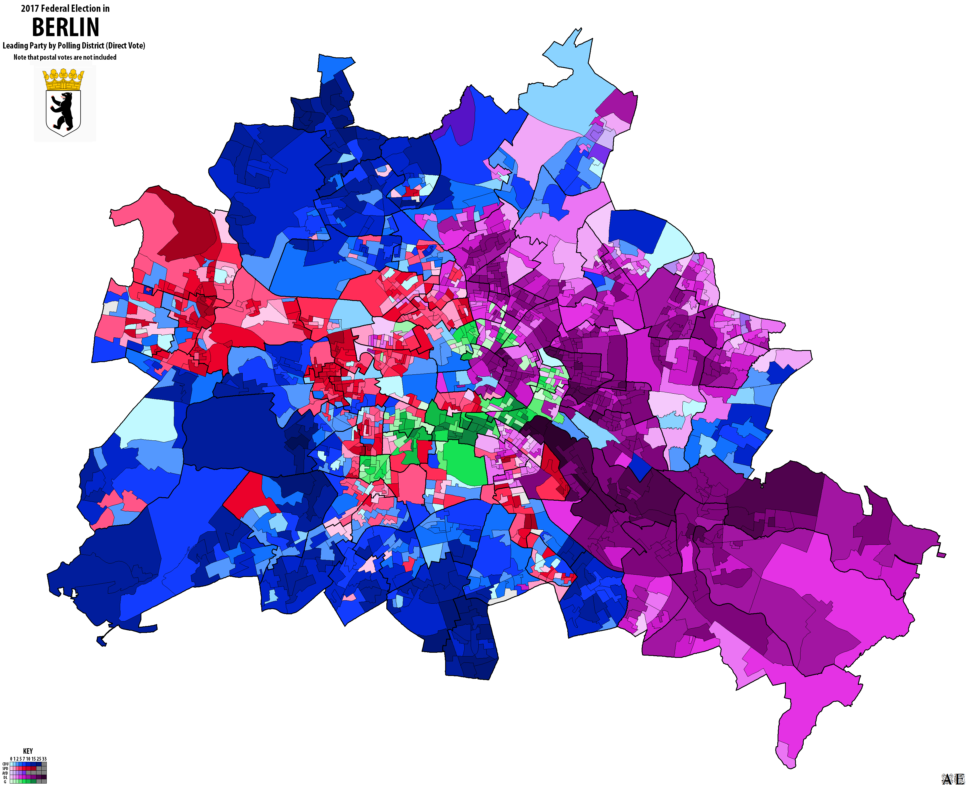
AKA Alun Ephraim. A very fine map but not a fan of that colour scheme as it makes it hard to pick out the AfD from Die Linke and the CDU. I realise it's because he's been doing German maps for ages and was already using blue for the CDU, but still.
I do like how the most Linke area of all is the bit around the Soviet War Memorial.
For the record this is what it looks like if you use a more contrasting (arbitrarily chosen) colour scale for AfD.AKA Alun Ephraim. A very fine map but not a fan of that colour scheme as it makes it hard to pick out the AfD from Die Linke and the CDU. I realise it's because he's been doing German maps for ages and was already using blue for the CDU, but still.

Don't some places (Phoenix springs to mind) have ridiculously low numbers of precincts?There's no set rule over how big a precinct can be. However, from my experience, the practical upper limit seems to be about 3,000 voters per district (precincts above this tend to get split the next cycle). Some precincts are quite small - normally because they match up to some village or something (it makes it easier to count and run certain elections if the precinct is co-terminus with municipal boundaries; my own precinct actually straddles two municipalities, so we have to have two types of ballots). While not a perfect measure, it does give a good idea where there's increased population density.
However, that doesn't stop unusual things from happening. There's one precinct in Missouri that only has 4 voters (where, interestingly enough, Clinton and Castle tied at 50% each). Missouri doesn't tend to have anything big, though I do know Nebraska has these stupidly large precincts in some areas that process half as many voters as your average Westminster constituency at a single site.
Don't some places (Phoenix springs to mind) have ridiculously low numbers of precincts?
That's about half the size of Manchester!Glendale, CA (among other places in that state) is just one big precinct in Dave's Redistricting.
120,000 voters IIRC.That's about half the size of Manchester!
Does the "State Senates" map report the composition of the entire house, or just the seats elected in that year?For a while I have been considering trying to consolidate all election maps for major U.S. offices in a presidential year onto one map.
As I am currently laid up with a sprained ankle, I've given it a go. Small preview below.
I'm going off Ballotpedia which I think uses the former, but you're right, I need to make sure of it. I think the former is more sensible as I think in some states it's geographical rather than multi-seat districts so a physically different part of the state would be voting every time?Does the "State Senates" map report the composition of the entire house, or just the seats elected in that year?
I don't know of anywhere that does use multi-seat districts. California, for instance, has four-year terms that are staggered based on the parity of the district number.I'm going off Ballotpedia which I think uses the former, but you're right, I need to make sure of it. I think the former is more sensible as I think in some states it's geographical rather than multi-seat districts so a physically different part of the state would be voting every time?
West Virginia does for one, though it's certainly the less common arrangement.I don't know of anywhere that does use multi-seat districts. California, for instance, has four-year terms that are staggered based on the parity of the district number.