Map Thread XV

Status
Not open for further replies.
Let's not forget the weirdness of the Saskatchewan-Manitoba Border:
li-rm-glenwood-map.jpg
 
Let's not forget the weirdness of the Saskatchewan-Manitoba Border:
li-rm-glenwood-map.jpg

The border follows the correction line, which actually makes MORE sense than a simple straight line when you're measuring things in mile long pieces. So you don't end up with oddly shaped pieces of land on either side of the border, everything fits the nice 1x2 mile blocks that where originally done during from the Dominion Land Survey.

It looks goofy on a map but for Joe Blow farmer it makes many fewer headaches.
 
1278 Onslaught.png

1278


The 1272-1277 Civil War in the Mongol domains between Kublai Khan and Kaidu split the Mongol world into factions. Ulus Jurchi, under Khan Mengu-Timur, supported Kublai. The IlKhanate, under Khan Abaqa, and the Chagatai Khanate supported Kaidu.
With the Civil War preventing support from the other Mongol Domains the forces resisting the Crusaders were limited. Tumans raiding Lithuania were diverted via Mazovia to strike through Silesia, scene of success in 1240.

Learning from the original invasion castles and fortifications had been built. Ottokar had also increased the armoured element of his forces, created a standing army and raised a force of light cavalry imitating his rebel Cuman allies. In 1272, this army boosted by Teutonic Knights and the English Crusader force under Prince Edward [soon to be King Edward I], met and decisively defeated the Mongols at Oels.

Poland threw off Mongol vassalage in 1273, contributing more men to the Crusader army, including their famous "Winged Hussars"
untitled.JPG
- the wings were thought to create a sound that un-nerved the enemy- and the combined army defeated the Mongols twice more in 1274, at Sandomeirz and Kolomija, the latter causing the Galich lands to rebel against Mongol overlordship.

In the south the Crusader army under King Louis IX of France met the mongols on the Verence River, by mid-day it seemed to be a Mongol victory but the arrival of Charles I of Naples [brother of Louis IX] with his Serbian allies, unfortunately too late for Louis who died of his injuries.


Edward returned to England to be crowned King in 1275 whilst Charles became distracted by his plans to invade the Byzantine Empire.

Defeats by the IlKhanate left Ulus Jurchi in a perilous state so they agreed a 5 year truce with the Crusaders to enable them to concentrate on the IlKhanate.
The Pope was not happy and absolved the Crusaders of their agreement but momentum had been lost.
___________________________________
You may notice I have adjusted the coasts of England and Holland to their state pre-the Great Storm of 1287
 
1280 Holy Roman Empire after the Cologne conclave.png

In 1280 the Electors of the Empire met, deciding to allow the emerging entities entry to the Holy Roman Empire, more as way to control them and prevent an over-powerful state forming on their borders.
The Duchy of Austria worried them enough in this respect.
 
So here is a historical map of Canada (labeled as 1850 i think) from the back of a Canadian geographic turn of the century map of Canada (this was beside a few zoomed in historical maps of Quebec, Ontario and the Maritimes.
IMG_5365.jpg

Zooming in on the west:
IMG_5363.PNG

Zooming again:
IMG_5361.PNG

What the hell is British Columbia's border doing way down there!?

As far as I know joint British-American Oregon went a ways south of that line along the New Spainish then Mexican border. I have no clue how the border ended up where it did on the map.

Just repeating this was on the back of a real historical atlas published by Canadian Geographic. But it looks pretty alohistorical to me.
 
13commonwealths_by_gottfreyundroy-db6m0n6.png

The 13 Commonwealths of the U.S.

No specific POD in mind. Inspired by Fallout, and I had some vague vague notion from Fo4 that it was done by Nixon.

My choice of capitals was arbitrarily, sometimes based on centrality, sometimes off of importance, sometimes as a cultural compromise.

Each Commonwealth has a population of around 25 million people to eliminate unequal senatorial representation.
 
Last edited:
So here is a historical map of Canada (labeled as 1850 i think) from the back of a Canadian geographic turn of the century map of Canada (this was beside a few zoomed in historical maps of Quebec, Ontario and the Maritimes.
View attachment 318452
Zooming in on the west:
View attachment 318446
Zooming again:
View attachment 318444
What the hell is British Columbia's border doing way down there!?

As far as I know joint British-American Oregon went a ways south of that line along the New Spainish then Mexican border. I have no clue how the border ended up where it did on the map.

Just repeating this was on the back of a real historical atlas published by Canadian Geographic. But it looks pretty alohistorical to me.

That's the Columbia District. We nearly had that land...
 
13commonwealths_by_gottfreyundroy-db6m0n6.png

The 13 Commonwealths of the U.S.

No specific POD in mind. Inspired by Fallout, and I had some vague vague notion from Fo4 that it was done by Nixon.

My choice of capitals was arbitrarily, sometimes based on centrality, sometimes off of importance, sometimes as a cultural compromise.

Each Commonwealth has a population of around 25 million people to eliminate unequal senatorial representation.
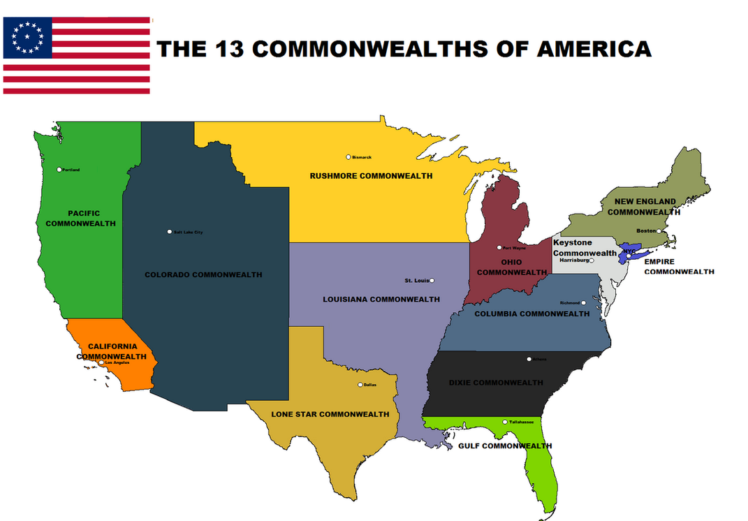
Forgot to mention- each common wealth has around 25 million people
 
XBAM Concept AkA the CONCEPT OF MADNESS

xbam.png


A new concept based on an idea I had this afternoon.
I'm thinking of scrapping VBAM, and doing an VBAM2/XBAM scaled Version of my Greater German Demon Empire.

Pros:
- Yooge
- It's based on MBAM, making it possible to expand it afterwards
- ton of detail
- communes could be added

Cons:
- Yooge (Took me 1 1/2 hrs to do this XBAM concept graphic)
- A pain-in-the-ass-ton of detail to MAKE
- Have to remake Germany entirely
- Won't do anything more than Germany and maybe the Teutonic Order, Denmark and Papal States Puppets
- Will take LONG until it's finished (first estimations on finishing this if I immediately start: September, probably... #BERAirport)


Reasons why I'm thinking of doing this:
VBAM is based on a Vicky 2 map which is unevenly upscaled. (~3.5 times) XBAM would've been based on MBAM and thus being a Robinson (like basically all other basemaps on this page)

Additionally, I have no hobbies and am... weird. Or mad? Who knows?
(This sentence was serious)


Please do notice that it's just a concept. I'm not promising anything for now, and I might abstain the idea. But I thought It'd be worth posting.
The odds are currently positive, unless something big/bad happens irl, Chances are good.
 
Top
Status
Not open for further replies.
Top