Affiliated States of Boreoamerica thread

This is a rough map of the continent, the first since a tiny thumbnail I made several years ago. Most of these borders are canonical, with the exception of those small plains states.

I'm interested in what the Dominion of Rupertsland is like. From the name, I presume it has a similar status to OTL Canada prior to its complete independence from the United Kingdom?

Rupertsland's a huge country, but its only good area for farming and inhabitation (the Prairies around OTL Alberta, Idaho, Saskatchewan, and Montana) is a long way from the sea and must be very difficult for Britain to govern.

There'll probably be some ports on Hudson Bay, e.g. OTL Churchill and Moose Factory; will ports on Hudson Bay be more important in TTL? I think they have to be due to Rupertsland's unfortunate geographical position. Churchill could serve as Rupertsland's primary port, with a road to TTL's equivalents of Edmonton and Calgary.

Rupertsland seems to be in a rather unique geographical position, and no OTL countries are quite like it. So I'm interested in its development. Did most immigrants to Rupertsland arrive from the ASB in the east, or from Oregon in the west, or directly from Britain via Hudson Bay? Or are most Rupertslanders indigenous?

Just some thoughts. A lot of this universe still needs fleshing out of course :)
 
Fantastic work!

Wonderful TL :)
The idea of a North America much more culturally and politically diverse but without numerous small wars is a very interesting utopia and the background work to back it up is honestly impressive.
Some questions:
Could you give a global image of the world since the "PoD"? I understood that Britain is sort of a mess and that France got a very different history than OTL, and of a massive Russia, but that's all kind of blurry and more infos would be great.
Also, since this TL seems based on oddities that never existed OTL, I wondered if there existed a sort of blend between Indian tribes and the French Coureur-des-bois? Perhaps also with a weird religious syncretism :D
On that point, how is religion in the ASB? I noticed that a lot of Indian seems to have converted to Christianism, is it broadly the case in the whole ASB or has some Indian communities - or even states - retained their traditional belief?
And finally, how are the Jews in this TL?

Anyway, keep up the good work :D
 
Last edited:
What year is this set in?

Present day. Some maps have shown points in history, but they show the date. Anything without a date is in the present.

Will Socialism start to spread?

Turquoise Blue has written the most about the ASB's poltics. Socialism has indeed been a force since the 1890s. The "Red Seventies" were the high point of their influence in the national government, and they are definitely still around. http://karnell.weebly.com/chief-ministers.html

Will there be any wars against Mexico?

The time of highest tension between the ASB and Mexico would be the last 3 decades of the nineteenth century. Mexico was aggressively encouraging settlers to homestead in the Great Plains, which put pressure on the indigenous people and on the small settlements of Louisianans and other ASB people who were already in the region. A war during that era would be interesting to explore, because at the time the ASB had no national armed forces to speak of.

This TL has been the best thing I've found here all day.

Thanks, and I'm sorry it's so many dozens of days after you posted. :)

Wonderful TL :)
The idea of a North America much more culturally and politically diverse but without numerous small wars is a very interesting utopia and the background work to back it up is honestly impressive.

Well thanks. It definitely is utopian. I read a blog recently about the proliferation of dytopias in AH... although I feel that it all comes from a culture that's just generally pessimistic right now. Either way, I'm happy to buck the trend. However I will say that there are lots of small wars. The states didn't stop habitually fighting amongst themselves until the midpoint of the 1800s. As the political architecture of the ASB matured, it managed to limit and contain these wars, eventually stopping them altogether.

Some questions:
Could you give a global image of the world since the "PoD"? I understood that Britain is sort of a mess and that France got a very different history than OTL, and of a massive Russia, but that's all kind of blurry and more infos would be great.

So... that giant Russian commonwealth is by far the most salient fact of world history and politics. It's far less realistic than the ASB itself, and I'm not ashamed to say it started as a joke. It's just that I found myself imagining the people and structures and government of my silly creation, and pretty soon I liked it. So the world situation has to take that into account. A lot of wars were fought by coalitions of nations trying to limit or break that powerful axis.

Breaking through some of the haze, I know that England (with Wales) constitute a kingdom. Scotland is a republic; so is France. Germany is divided up: Brandenburg is a strong northern power and is in de facto control of the ports of Lübeck and Hamburg (essential to prevent Sweden/Russia from controlling the entire German coast). There is a loose federation in the center of Germany. A descendant of the Habsburg empire still exists in Central Europe and part of the Balkans. China is truncated and still has a few foreign concessions in certain ports.

Beyond these places I truly don't have anything. That's always been my prefered style, starting from minor details and working my way up to the grand picture. People I've collaborated with can sometimes find that infuriating, but evidently that's just how I work.

Also, since this TL seems based on oddities that never existed OTL, I wondered if there existed a sort of blend between Indian tribes and the French Coureur-des-bois? Perhaps also with a weird religious syncretism :D

That is precisely the core of the identity of many of the Francophone states. People from Huronia, the Upper Country, Illinois, and Assiniboia would all describe their states' origins in almost exactly those terms. It's sort of a romantic simplification, but the Indians and coureirs-des-bois are important to how those states define themselves. I've looked to Mexico and the concept of mestizaje as something of a model. I admire the national identity that Mexico constructed for itself in the twentieth century, able to look to the ancient empires and say "That was us" in a way that North Americans in OTL really do not do with their deep past, because our national identity is based more on settlers coming over and starting fresh.

On that point, how is religion in the ASB? I noticed that a lot of Indian seems to have converted to Christianism, is it broadly the case in the whole ASB or has some Indian communities - or even states - retained their traditional belief?

Like you said, syncretism definitely happened. The almost universal colonial pattern in OTL has been the eventual spread of Christianity, but with indigenous practices surviving sort of underneath it all. That was the case in most of the ASB.

What facilitated the spread of Christianity? One cause is that even in OTL, a lot of the Jesuit and Moravian missionaries were legitimately good at what they did. They learned and lived the culture of the villages they stayed in, and they became integral parts of the mixed "middle ground" society. In TTL they fit in very comfortably, and we see them popping in and out of different episodes in the history, often occupying key roles mediating between the White and Indian worlds. In TTL you will also see English missionaries doing the same thing, something rare in OTL. The English were so demographically dominant in our timeline that they didn't much bother trying to convert the locals, and when they did, they didn't bother with any kind of cultural negotiation; they expected converts to adopt every aspect of English Protestant culture. In TTL that demographic dominance was much less pronounced, which meant English missionaries had to be more conscientious, and so you find Anglican and Baptist and Methodist churches among many of the indigenous communities.

That's not to say that things went smoothly in all cases. With no Spain-style empire imposing the religion from above, it's natural that the original practices survived in pockets. Places like Iroquoia and Chicasaw have some portion of the population that never embraced Christianity. And it's also common in recent years for traditional religious practices to be revived even where they did not survive. Mixed/Metis people are as much a part of this movement as people who identify as fully indigenous.

And finally, how are the Jews in this TL?

What I know is this: Alaska, California, and Oregon attracted many Russian Jews, along with a few other persecuted groups, in the 19th and 20th centuries. New Amsterdam was known as a place of religious pluralism in TTL, just like OTL (and that reputation really does go back to when it was a Dutch town), and so it has a vibrant Jewish population as well, as does Philadelphia. Nationalism worked in odd ways in TTL, so we shouldn't expect Zionism to be quite the same, either. But at this point I'm not ready to decide whether a Jewish state exists or not.

I'm interested in what the Dominion of Rupertsland is like. From the name, I presume it has a similar status to OTL Canada prior to its complete independence from the United Kingdom?

By now it's fully independent. So it's like Canada or any of the other Commonwealth Realms.

Rupertsland's a huge country, but its only good area for farming and inhabitation (the Prairies around OTL Alberta, Idaho, Saskatchewan, and Montana) is a long way from the sea and must be very difficult for Britain to govern.

I was very careful to draw the map so that Rupertsland includes that belt of land; IMO that is the only way to make it viable as a country. Rupertsland's origins are in the communities of workers for the Hudson's Bay Company. A great many of them were French speaking Metis who came from Canada and the Upper Country. Their work took them far beyond the reach of Canadian authority, and there was some mixing and interacting with settlers from England and Ireland; by the second quarter of the 1800s the Rupertslandians (?) had emerged as a distinct culture on the prairies. A great many were loyal subjects of the company-colony. The villages of Assiniboia, adjacent to the ASB, had the strongest links back east, and this was the part that at some point rebelled and became a state. That more or less purged the separatist element, and the next large settlement movement of Rupertslandians, in the Montana-Saskachewan region you described, was made up largely of loyalists. The settlements there became the nucleus of the modern state and the driving force behind its reorientation from a colony focused on exploiting the resources to a distinct civil society.

There'll probably be some ports on Hudson Bay, e.g. OTL Churchill and Moose Factory; will ports on Hudson Bay be more important in TTL? I think they have to be due to Rupertsland's unfortunate geographical position. Churchill could serve as Rupertsland's primary port, with a road to TTL's equivalents of Edmonton and Calgary.

Unfortunate is right. From the moment the first railroad was built, the most active ports for Rupertsland's trade have been on the West Coast. Protectionist policies have promoted the use of the Bay ports, but they just aren't practical for most purposes due to ice and the rugged intervening terrain. The majority of its trade goes through Oregon or California.

Rupertsland seems to be in a rather unique geographical position, and no OTL countries are quite like it. So I'm interested in its development. Did most immigrants to Rupertsland arrive from the ASB in the east, or from Oregon in the west, or directly from Britain via Hudson Bay? Or are most Rupertslanders indigenous?

The original population was made up of Metis from the Francophone ASB and English immigrants. There was a lot of cultural interchange between them and the indigenous people of the prairies. Their numbers were later augmented by other immigrants, especially from various parts of the ASB. The big northern lands are majority indigenous today, but the population centers are not.

I hope that addresses your questions in an okay way. Thanks very much for the interest.

 
Last edited:
The state anthem "Pennsylvania, Happy Land" was composed by Philip Phile for the inauguration of Pennsylvania's fourth elected governor, John Peter Muhlenberg. The words were written some years later by the statesman and academic Joseph Hopkinson.

Pennsylvania, happy land!
Fast by thee thy sons shall stand,
Stout voices raised in freedom's song,
Stout voices raised in freedom's song!
Armed with our rights and liberty,
Our hopes are fixed on heav'n and thee.

Independence be our boast,
Ever mindful of the cost,
Grateful to those gone afore,
Sound its praise from shore to shore.

Forever faithful let us be,
Rallying round our liberty,
As a band of brothers joined,
Peace and safety we shall find.
 
This is a nicer, more accurate version of the Upper Country map.

Upper Country REBOOT FYEAH.png
 
Maybe St Paul could be called Pigs Eye?
from Wikipedia: " The settlement originally began at present-day Lambert's Landing, but was known as Pig's Eye after Pierre "Pig's Eye" Parrant established a popular tavern there. When Lucien Galtier, the first Catholic pastor of the region, established the Log Chapel of Saint Paul (shortly thereafter to become the first location of theCathedral of Saint Paul), he made it known that the settlement was now to be called by that name, as "Saint Paul as applied to a town or city was well appropriated, this monosyllable is short, sounds good, it is understood by all Christian denominations" "
 
That's interesting, and a good idea. So far I haven't delved much into the local histories of the western end of the Upper Country. "St. Paul" seemed like a nice old missionary type name, but I like the quirkiness of a major city called Pigseye. I know the Twin Cities are at a natural point on the route from the Mississippi to the region of the Red River of the North, so it's logical that two cities would grow up there. I also know that in TTL the growth of local institutions was quite slow, maybe because of its position right on the border. No "upper Mississippi country" was wver created, and the region was just lumped together with The Massif in 1890. At that point the cities there were still rather small and really came into their own in the early 20th century.

The population is pretty diverse; it has trade links to both English and French speaking regions, as well as indigenous. It's almost certainly bilingual (English and French), and Anishinaabe and Dakota speakers are in the area as well, at least in the rural areas nearby. Pigseye is a fun idea for a name, and it works given the English-speaking presence.
 
Another update: the collection of state flags so far (plus one supra-state region and one subdivision).

I still have no design for the national flag of the ASB. My original idea had been that the main symbol should be a turtle; I wonder if that's just a dead end, because I haven't even sketched a design that I like.

ASB FLAGS flat.gif
 
Something like this, then? :p

ak-largeflag.png

Ooh, I like it! Nice design, and it's a constellation, a group of affiliated stars, plus the north or boreal star!

Edit: I just realized that this is the existing flag of Alaska, not something original:p, but a similar theme could be used for an actual official ASB flag, maybe with some other symbols added to it?
 
Last edited:
Ooh, I like it! Nice design, and it's a constellation, a group of affiliated stars, plus the north or boreal star!

Edit: I just realized that this is the existing flag of Alaska, not something original:p, but a similar theme could be used for an actual official ASB flag, maybe with some other symbols added to it?
Yep, it's Alaska. :p
 
OTL St Paul is there cause thats about as far up river as steamboats could get and Minneapolis is there cause of the waterfalls that powered the flour mills
 
You could have the Big Dipper on a dark blue background as the ASB if you want.

It works in theory and fits the country's overall aesthetic. I wouldn't want to use it because that's the flag used for Ill Bethisad's North American League. It has its own song and everything. I've been part of IB for years and already worry that the ASB is too similar to the NAL *there*. The inspiration for this project comes from a very different place - the NAL is basically a more humane British Empire, while the ASB is about common ground among English, French, Indians, and Spanish. But since Ill Bethisad was the first alternate history-like project I ever did, I'm sure it has left its influence on what I do, and you can certainly find similarities. Like if you compare the maps, both have a surviving New Sweden, two Floridas, one Carolina. I think the similarities are mostly superficial and are justified by the backstory, but I don't want to use the same flag and really make it look like I'm ripping off ideas.

What about a bat among stars? :v

That's actually not bad. If it can be justified in-universe while making a good design, it might work.

More seriously, why the turtle symbolic for the ASB?

A turtle is one of the main indigenous symbols for North America. A number of cultures have myths that envision the continent as a giant turtle's back.
 

Gian

Banned
Well, I kind-of used the Big Dipper in my (long-abandoned) Sovereign League of North America project too, so I saw no objections to using it.
 
Just wanted to say keep up the great work False Dmitri! Glad to see this still going! :)

And while's there's a lot I can comment on/ask about (especially in regards to Mexico), I'll keep it short for this post.

For the national flag, how about a simple two color (dark blue and white) flag with a stylized turtle outline in the center and the state-representing stars organized as two "pillars" on the far left and right on the flag?

And one question - What are the cities of Chicagou, Detroit, and New Amsterdam like?
 
Just wanted to say keep up the great work False Dmitri! Glad to see this still going! :)

And while's there's a lot I can comment on/ask about (especially in regards to Mexico), I'll keep it short for this post.

Not much has been developed, but I've been going with the basic plan you wrote. A period of monarchy under a Spanish royal, then after they lost control of California they entered a phase of pretty aggressive expansion onto the Great Plains, lots of indigenous peasants homesteading up there. That's the basic plan.

For the national flag, how about a simple two color (dark blue and white) flag with a stylized turtle outline in the center and the state-representing stars organized as two "pillars" on the far left and right on the flag?

Nice idea, can you make a mock-up? Otherwise I'll try it later.

And one question - What are the cities of Chicagou, Detroit, and New Amsterdam like?

Chicagou and Detroit have official descriptions. I'll quote them.

Detroit Country: The capital. A densely populated region - in colonial times, the whole country was said to resemble one continuous village. The country speaks French, though most people in the towns and countryside have lots of Indian blood. The city itself has some fairly grand architecture suitable for the capital of a big state. The early 20th century saw a good deal of industrial development, though not on the scale of our world's Detroit.

Chicagou Country: Chicagou is one of the major commercial centers of not just the Upper Country, but of the entire ASB. It is located in a strategic spot where the Mississippi watershed comes very close to Lake Michigan. Small-scale canoe trade fed a growing village, but the real growth began after 1850. A canal to the Illinois River created a new commercial highway, diverting trade away from the traditional route through the Ouisconsin and Renard Rivers to the north. Modern roads and railroads followed a bit later, and by the 1890s the city was a booming industrial center with a diverse immigrant population. Chicago Country, already taking shape before the boom, was firmly established with a separate legislature and judiciary at the time of the canal's construction. Chicagou has since then been a rival to Detroit, typically seen as the rough, burly counterpart to the more refined and cultured state capital. Despite this perception the city has a vibrant cultural scene of its own. A "city of neighborhoods," Chicagou is really a patchwork of small local communities, some of them stretching back a century or more, others of more recent creation by groups of newcomers.

I haven't written a full description of New Amsterdam yet. But so much of OTL New York's culture - and even US culture in general - has roots in New Amsterdam that it's going to have some parallels to OTL. It's very big, fast-paced, incredibly diverse. Dutch is the main lingua franca but hundreds of languages can be heard on the street. The wall at Wall Street was built up into a stone fortress in the later 18th century, so today the lower end of Manhattan has a very colonial, Old City feel, with the governor's palace at the far southern end. The rest is a living modern city, somewhat comparable to OTL NYC. There's a lot still to fill in, though. New Amstterdam is one city I'd actually like to map in detail.

Well, I kind-of used the Big Dipper in my (long-abandoned) Sovereign League of North America project too, so I saw no objections to using it.

That was a fun project. But that was directly based on Ill Bethisad, right? So it's a different sort of thing. I really want to avoid that.
 
Not much has been developed, but I've been going with the basic plan you wrote. A period of monarchy under a Spanish royal, then after they lost control of California they entered a phase of pretty aggressive expansion onto the Great Plains, lots of indigenous peasants homesteading up there. That's the basic plan.

Ah. Well I'm glad I was able to help. :) I'll definitely post more ideas later on if you'd like - although I will say that I'm in favor of Mexico annexing the two ? territories on the map instead of them being independent.

Nice idea, can you make a mock-up? Otherwise I'll try it later.

I haven't done image editing in a long time, but I'll try to have an extremely rough edit on Monday.

Chicagou and Detroit have official descriptions. I'll quote them.

Very cool! Nice to see Detroit doing well. Any idea how populous they are? I'm also kind of curious what kind of cultural influence they have outside the ASB since they might be among the biggest French speaking cities in the world.

I haven't written a full description of New Amsterdam yet. But so much of OTL New York's culture - and even US culture in general - has roots in New Amsterdam that it's going to have some parallels to OTL. It's very big, fast-paced, incredibly diverse. Dutch is the main lingua franca but hundreds of languages can be heard on the street. The wall at Wall Street was built up into a stone fortress in the later 18th century, so today the lower end of Manhattan has a very colonial, Old City feel, with the governor's palace at the far southern end. The rest is a living modern city, somewhat comparable to OTL NYC. There's a lot still to fill in, though. New Amstterdam is one city I'd actually like to map in detail.

Very cool! I especially like how you have lower Manhattan as a historic district. I wonder if that means Harlem is the part with the massive skyscrapers and the National stock market. ;-)

Also, does New Amsterdam occupy the same area as New York or does it include other areas like Yonkers or Jersey City?
 
It's California time!

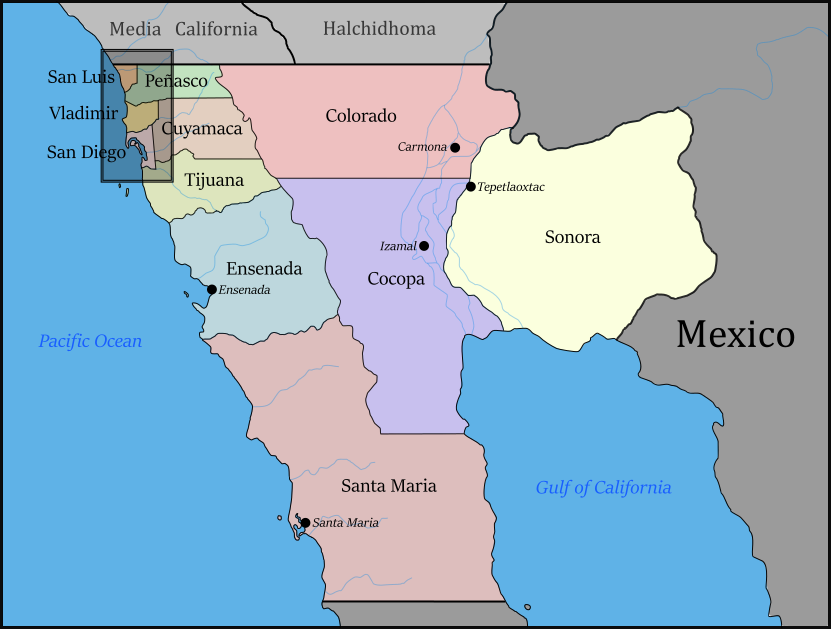
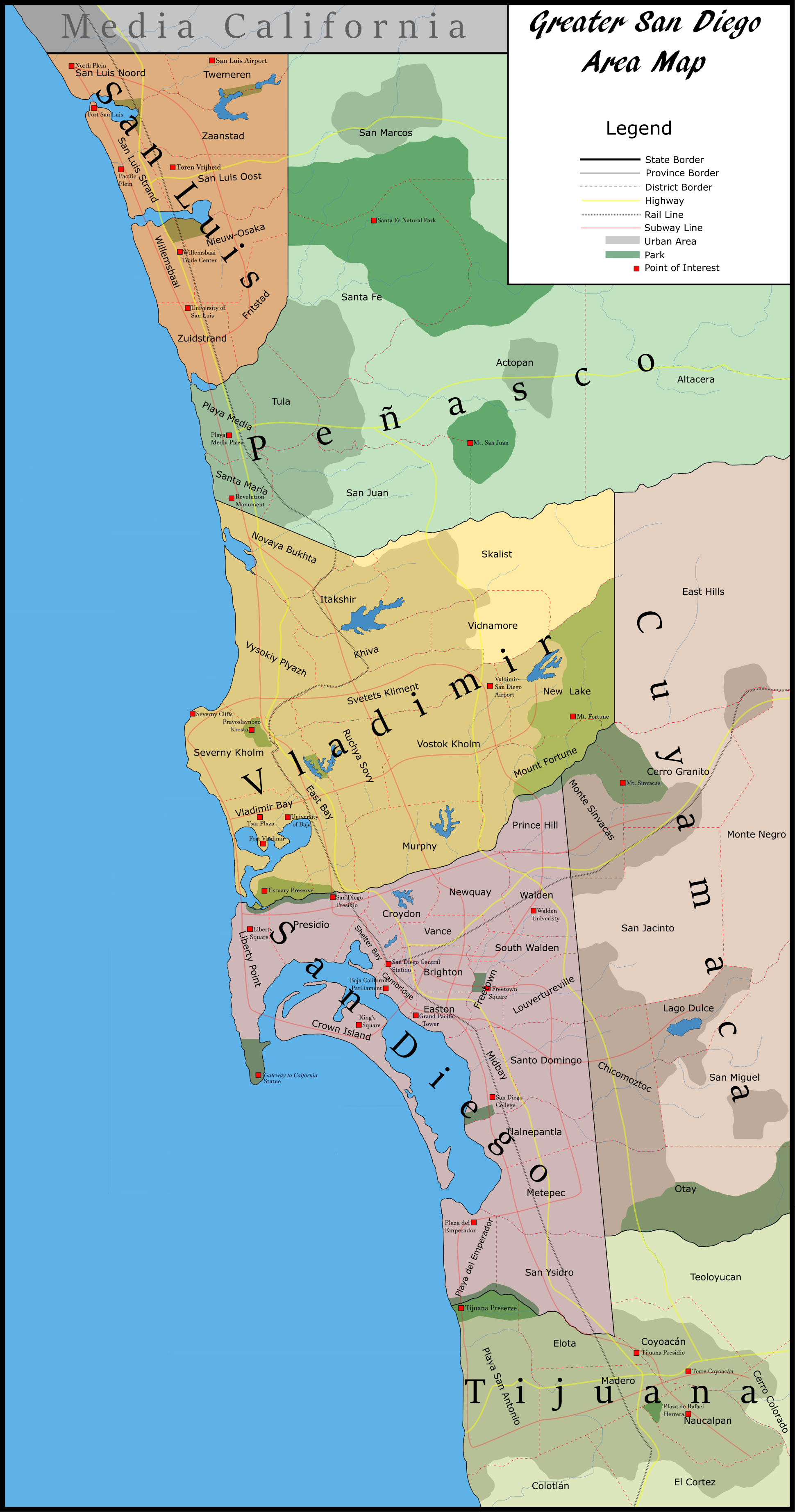
I have two maps here. First, I started a map of the Baja California state of the Californian Union. I decided to also add an inset map of the San Diego metropolitan area. Originally it was just an add-on to the main map, however, rather like The Lord of the Rings, the map grew in the making, and turned out much more complex than what I had originally imagined. But to start, a description of Baja California's history.

______________________________________________________________________________________

Baja California. The southernmost state of the Californian Union, and including its second largest city, San Diego. Although a Franciscan mission was established on the San Diego River in the 1700s, the usefulness of the San Diego Bay as a harbor was first noticed by the English, who created Fort San Diego, a fort, harbor, and trading post on the bay in the 1830s. Shortly after, Russia, interested in denying England dominance in southern California, created Fort Vladimir just north at a marsh they dredged into a harbor and named Vladimir Bay, and farther north, New Netherlands established Fort San Luis. Meanwhile, Mexico founded the city of Tijuana, which would become the capital of Mexican Baja California, to the south of San Diego. The three forts developed into small cities and saw little conflict during the Gold Wars, which were focused on San Francisco and the gold fields of in northern California.

After the Gold Wars, San Diego, Vladimir, and San Luis prospered, and much grew from immigration from their respective ruling countries, Mexico, East Asia, the ASB, the other Californias, and many other parts of the world. One major wave of immigration to the region occurred after the 1879 completion of the Southern Transcontinental Railroad, from Charleston, through Louisiana and Mexico, to San Diego. Just a year later, Carolina abolished slavery. Tens of thousands of freedmen traveled west, looking for a new life. Some white Carolinians came to San Diego, too, as well as immigrants from other parts of the ASB. San Diego being the terminus of the railroad was one factor in establishing San Diego as the largest of the three cities.

The three cities were part of the alliance of states and colonies known as the Californian Union. Many in the cities supported greater integration of the Union, as it would improve trade between them and the rest of California, and their current status as enclaves in Mexico. However, Mexico was strongly opposed to Californian integration, as they feared the loss of their Californian provinces. During the 1890s, events in northern California increased support for integration, and following negotiations between numerous parties, including San Diego, Vladimir, San Luis, the other states of California, Mexico, England, Russia, and New Netherlands, they agreed that the three cities and northern Baja California would be united into a new state of Baja California in the now more integrated Californian Union, with San Diego as its largest city and capital. The southern part of the peninsula would remain a part of Mexico, and the colonizing powers of the three cities would retain special privileges in the area of their former colonies for trade and travel. John Cambridge, previously Governor of San Diego, became the President of Baja California.

Cambridge extended San Diego’s English minority rule to the rest of Baja California, instituting a government in which the English, only 6% of Baja’s population, were the upper class above all other ethnicities. As president he had effectively dictatorial powers. However, Cambridge was generally popular because he maintained San Diego and the other cities’ status and centers of trade and business, and made Baja wealthy and stable compared to the rest of California. During the early 20th century, Cambridge improved roads and rails in Baja, created a subway system in the San Diego area, and built several reservoirs to provide water to the arid region. After decades of ruling, Cambridge died of old age in 1937, and was succeeded by Christopher Hawkins, who continued Cambridge's policies and maintained the status quo of Baja California from 1937 to 1956, when he too died.

Hawkins was succeeded by George Leigh. Many people of Baja hoped for for an end to the policies of English rule and authoritarianism, but Leigh proved to be even more against reform than his predecessors. Leigh only decreased the rights of non-English and ignored directives from the Californian Union, which had too many of its own troubles to stop him. Many countries stopped business and trade with Baja, so Leigh ended English, Russian, and New Netherlands privileges in their former ports. Wealthy businessmen, some of the strongest supporters of government, now turned against Leigh. When protests were ended with force, they became rebellions. During the 1960s, The government lost control of most rural areas, and the cities became battlefields between the government and rebels. In 1968, the upper Californias intervened and invaded Baja. George Leigh fled to Mexico, and the old Baja government collapsed.

Popular backlash against the authoritarian Leigh regime caused support of localism and anti-authoritarianism, and the new government of Baja California was confederal, delegating power to its provinces, which in turn delegated some power to individual towns and communities. Baja had been ruined by war. The 70s were marked by poverty and corruption, and the 80s were little better. It was not until the 90s that Baja improved, as trade and business returned to the cities and Baja became a common tourist destination. Baja has developed unevenly; the central parts of its main cities are now modern and wealthy, but many other areas remain undeveloped and impoverished. Baja is now a representative democracy, although in some places corruption and lawlessness are still common- though still better than many of the failed states in the eastern part of the Californian Union.

baja_california_by_doctor_president-dac5as1.png


San Diego Area Inset Map:
san_diego_city_by_doctor_president-dac5aaa.png
 
Last edited:
Top