Kaiphranos
Donor
Welcome to the voting thread for the eleventh round of the ABCs! Topic of the round: Kenya! Color of the round: 60C860. At stake: the title of "Khan of K."
As always, vote for whichever map you think was best!
Baconheimer

January First-of-May

jetpack

Mr.J
wilcoxchar

(And once you've voted, stop on by the main thread to see what this week's challenge will be!)
As always, vote for whichever map you think was best!
Baconheimer
January First-of-May
Nowadays, when people see "Portuguese East Africa", they pretty much always think "Mozambique". Heck, even Wikipedia's article on Portuguese East Africa is named "Portuguese Mozambique".
However, while for more than half of the history of Portuguese East Africa it was indeed confined to Mozambique, that was not always the case; in the 16th and 17th centuries, it stretched north, along the coast, up into modern Tanzania and Kenya, and even (some sources say) a bit into modern Somalia (well, the country named that on the map - I won't be going any deep into the situation of modern Somalia, as it's at best tangential to this topic). Indeed, the very first Portuguese colony in East Africa was established in Malindi, in modern Kenya - during Vasco da Gama's voyage in 1498.
This all ended in the late 1690s, when the Omani army, through repeated attacks, conquered all the Portuguese colonies and outposts north of the modern Mozambique, and annexed it into the Omani sultanate of Zanzibar (named for its local capital, an island that itself was previously a Portuguese outpost).
But, as already said, Portuguese presence in this region did exist; and this map tries to list some of the major Portuguese colonies and outposts in East Africa north of Mozambique, with approximate dates when they actually were Portuguese. It might be bad-looking... but, well, maybe one day someone could do better!
jetpack
Mr.J
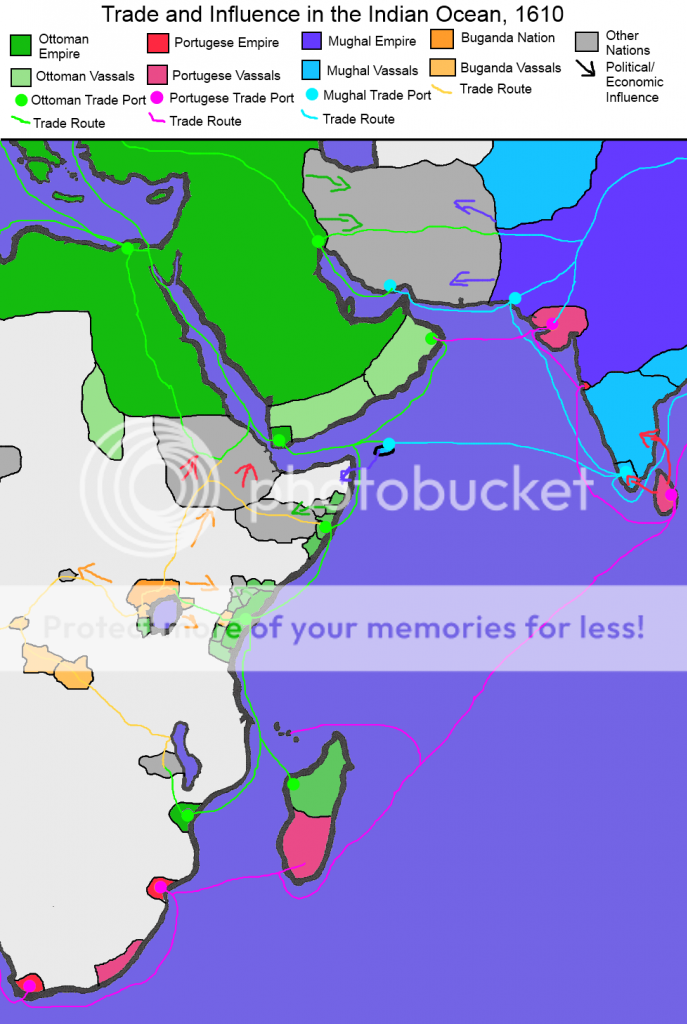
Our POD involves greater Portugese success while Spain takes longer to unify, resulting in a weaker Habsburg empire and thus a stronger Ottoman Empire. As such, a major area of economic competition is the Indian Ocean area, with Ottoman, Portugese and Mughal trade fleets, warships and explorers plying the waves. For now (1610), the "Three Brothers of the Sea" are at peace, but this is unlikely to last too long.
Meanwhile, the Baganda Nation has become a major power in Africa: their anti-slave-trade efforts rankle Turk and Portugese alike, but they are too far inland for the Ottomans to consider sending a punitive expedition yet. A slow struggle for influence, then, across the plains of Kenya and Tanzania, is the order of the day.
wilcoxchar
(And once you've voted, stop on by the main thread to see what this week's challenge will be!)