You are using an out of date browser. It may not display this or other websites correctly.
You should upgrade or use an alternative browser.
You should upgrade or use an alternative browser.
The NEW Our TimeLine Maps Thread!
- Thread starter Thande
- Start date
xt828's signature carries the most current copy of the QBAM, currently this.Anyone have a large size map showing national borders like the one here? (I messed up my copy, as you can, see). I went to the map directory, but the only large maps I see are of Ireland..
Yes, I know the reply is late, but I still think it's worthwhile to remind folk.
All things considered, this is probably already here somewhere, but it's so flipping epic it deserves a repost anyways.
http://geacron.com/home-en/?&sid=GeaCron108969
http://geacron.com/home-en/?&sid=GeaCron108969
Does anyone have a Q-BAM sometime around 1840-1846?
Bumping. I need that Mexico border.
An update to this map series posted back on page 180:
I've learned that there was a Belgian sector in Germany, at first in the British zone but then extending to parts of the American zone. It was started in April 1946 and expanded in October 1946 and again in 1952 (this time obtaining districts in the American Zone). In the meantime the Canadian Army of Occupation Force was withdrawn from Germany by June 1946 (a separate map isn't shown for June 1946, only an updated map for October 1946 with the CAOF sector removed).
In addition to the Canadians, Belgians and Luxembourgers, the Danes and the Norwegians also sent occupation forces (A Danish Occupation Force or Danish Brigade and a Norwegian Brigade) to Germany in the British Zone. I am not sure as yet though if like the Canadians, Belgian and Luxembourgers they were given operational autonomy and defined sectors under British/American/French command (French command in the instance of the Luxembourg forces, and American command for the Belgians in the American Zone)
I asked for the same thing yesterday in the Map Thread.
Here you go:
Can I have one of those beautiful Valdemarian maps of Europe of 1871, just before the Franco-Prussian War, please? And one for 1866, just before the Germano-German (Austrian) War?
Also, could one upload the Valdemarian series to the Wiki?
Figured I'd post some OTL map find here. pulled from http://www.globalsecurity.org/military/world/russia/maps-cccp.htm What's interesting about this map is that the parts of Afghanistan annexed by the Soviet Union loosely corresponds to non-Pashtun regions of the country and closely follows local geography too. The parts of Iran and China annexed are more loose. The Iranian section cuts without regard for geography, nor does it follow any ethnic or linguistic lines.

Immediate aftermath of WWI in Hungary and Romania border

The line denoting territory Germany hoped to recovered comes from this text http://books.google.com/books?id=ne3S9ibdfi8C
The authenticity I do not know. However, it is a border I find rather interesting in use of a "Weimar survives" map or timeline.

Different borders proposed/negotiated in aftermath of American War of Independence.


Immediate aftermath of WWI in Hungary and Romania border

The line denoting territory Germany hoped to recovered comes from this text http://books.google.com/books?id=ne3S9ibdfi8C
The authenticity I do not know. However, it is a border I find rather interesting in use of a "Weimar survives" map or timeline.

Different borders proposed/negotiated in aftermath of American War of Independence.

Different borders proposed/negotiated in aftermath of American War of Independence.
Could someone put the border proposed by France on a worlda? I tried but I couldn't get it right.
So Yemen is supposed to become a federation of six regions and this is how it is likely to look.....guess this means the worlda and QBAM will have to be updated in the future.
Alex Richards
Donor
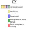
Bravo, though a key might be useful for those who aren't as familiar with the distinction between Unitary Authorities and Non-Metropolitan Counties, County Boroughs, Municipal Boroughs, urban Districts and Administrative Counties as you and I are.
Thank you so much for this interesting link
If you've wanted a rather accurate map of the areas to be ceded to the Finnish Democratic Republic by the Soviet Union, along with the areas to be ceded by that government to the Soviet Union, the following link has that for you: http://digi.narc.fi/digi/view.ka?kuid=12696565
Share:


