Week Of Devastation - Hurricane Andrew

August 23, 1992 (10:00 PM EST):

For 66 years, Miami had been living on borrowed time, and most of its residents knew it. Situated at the tip of South Florida in one of the most hurricane-prone areas in the world, the city had avoided a direct hit from major hurricanes since the Great Miami Hurricane of 1926. Since then, the city's population had quadrupled, while the metro area as a whole had experienced even more explosive growth. In 1992, the Miami metro area had more than 4 million people, it was a world city in every sense of the world, and continued to grow as more and more people flooded into the city, one of the most beautiful in North America.

Hurricane Andrew now loomed, posing the biggest threat the city had ever faced. The massive storm was reported to be a Category 4, but as meteorologists tracked the storm on its final approach toward South Florida, they realized in horror that the storm had begun a rapid intensification as it crossed Eleuthera Island in the Bahamas. Its pressure had dropped to 926 millibars and though its last estimated wind measurement was 145 miles per hour, no one really knew just how fierce the storm was until it actually crossed onto land.

The scariest thing that those tracking the storm noticed, however, was that the storm had taken the tiniest of jogs to the north as it made its final approach. Those in Miami who still had electricity could see it on the live weather reports, the storm was edging north as it approached the coast. The eye was heading right toward downtown Miami.

(NOTE: This TL, as you can tell, alters the course of Hurricane Andrew as it approaches landfall, taking it right into downtown Miami instead of making landfall further south in Homestead. As you can tell from the title, I have other plans for this storm as well as it makes its way toward the Gulf Coast. This is my first TL, so any advice/criticism you might have is welcome, no matter how harsh :eek:).
 
You realize the eastern side of a Hurricane is stronger than the western and you've actually lessened the damage, For instance Katrina totally screwed Biloxi,MS but spared New Orleans the worst of the storm damage (levee failure was a engineering fail not the storm itself). It's actually very hard to increase the damage done by Andrew to Metro Dade. Miami was hit by the strongest part of the storm (eastern) the Eye of the storm isn't really going to up the damage all that much. Now stalling Andrew in place like Hugo did to Charleston SC would up the damage exponentially but would require another miracle to accomplish.
 
Actually, when the hurricane went south to Homestead it spared Miami the worst winds of the eyewall. Andrew was a very compact storm, the most intense winds only extended about ten miles from the eye, which passed about twenty miles south of downtown Miami. Here, the downtown area is exposed to the entire eyewall and the 150+ mph winds within. Basically, look at these scenes of devastation to Homestead:

http://www.nhc.noaa.gov/gifs/1992andrew2.gif
http://photo.accuweather.com/photogallery/2009/8/500/1e1460bf2.jpg
http://naturaldisasteratlas.weebly.com/uploads/5/1/2/3/5123992/877232_orig.jpg

And put that right over downtown Miami. Every skyscraper will have nearly every window blown out, the storm surge hitting the coast will be several feet higher, etc.
 
August 24, 1992 (4:00 AM EST):

"Good morning, we're live in the Weather Channel forecast center, it's August 24th, 1992, history in the making as Hurricane Andrew is now making landfall in south Florida, we're talking about the Miami area."

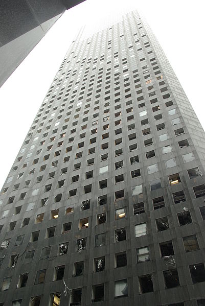
Those were the words of Weather Channel meteorologist Jim Cantore in the early morning hours of August 24, 1992, broadcasting the landfall of Hurricane Andrew to the world. At that moment, Miamians who had faced the brunt of the hurricane's winds took the briefest moment to crawl out of their shelters and survey the devastation around them. The Miami skyline was shattered, the Southeast Financial Center had practically every window in the building broken by the 150 mile-an-hour winds that had whipped across the city from the western eyewall. People began milling through the streets now, not many, as those in South Florida knew that the eye of the hurricane was a false calm, but tourists stuck in the city by flight cancellations comprised a significant number of those now walking the streets and surveying the damage, tiptoeing around fallen glass.

Inside the Government Center, county officials were hunkering down, having heard most of that building's windows shatter in the storm. They could see people outside, some of the people in the building tried calling to them to get them to get back to their shelters, but few heeded the warnings. The massive storm surge had washed up the beach and into some of the city's streets, though the waters had only washed away two people thus far, a pair of tourists who had foolishly tried to evacuate in their car at the absolute last minute.

As the winds began to pick up, a thankfully vast majority of those who had come into the streets during the passage of the eye over the city made it safely back to shelter. Of those who realized too late the danger they were in, few made it back alive. The eastern eyewall thrashed the city with winds topping 165 miles per hour, the nearby Hurricane Center recorded a gust of 216 before being ripped apart by the fury of the storm's winds. People hunkering down in skyscrapers reported seeing what looked like multiple tornadoes lashing the city, it was in Andrew that these would be identified as "mini-whirls", vortexes seen in especially powerful hurricanes that cause the bulk of the wind damage from the storm. The storm surge continued to rise, flooding city streets with waters nearly 18 feet deep in some places and washing thousands of cars and boats, and dozens of people out to sea.

As the first reports of the storm came in and a horrified America awoke to see the Miami skyline, a wrecked cluster of shattered windows and in some cases even damaged building facades, the preliminary death toll was reported at 59 in the city itself and nine in surrounding suburbs, including a single death in Homestead, some 20 miles south of downtown Miami and of the full fury of the storm. That initial number of 68 dead from Andrew would surely rise in the coming days.
 
Turkey Point took a direct hit from Andrew IOTL (it's 25 miles south of Miami) and survived, it would survive easily ITTL.
 

The Sandman

Banned
I'm assuming that once it finishes with Miami, it's going to hit either New Orleans or Houston? Both are close enough to the OTL track that a diversion in that direction would be reasonable.
 
August 24, 1992 (8:30 AM EST):

Hurricane Andrew emerged over the Gulf of Mexico as a Category 3 storm with winds of 130 miles per hour, leaving a swath of destruction in its wake along its path across South Florida. There was absolutely no doubt Andrew had been a Category 5 when it made landfall in Miami, and as news media began to flock to the scene, one of the big questions they had was why people weren't warned of the storm's true strength before it made landfall? The meteorologists at the National Hurricane Center, who were already completely swamped with Andrew's activities in Florida and were continuing to track the storm as it re-emerged over the warm waters of the Gulf, gave two reasons for not issuing an alert in the minutes before landfall.

The first reason they gave was that the storm was not suspected to be a Category 5 until immediately, perhaps 15 minutes, before landfall, the system had been undergoing rapid intensification and no one knew just how strong the storm was when it finally hit Miami Beach. The second reason they gave was that the difference between a Category 4 and a Category 5 in this situation was, for the most part, symbolic. Upgrading the storm's status would've caused an unnecessary panic and people who hadn't evacuated might try to do so at the last moment, getting themselves killed.

Speaking of evacuations, though there were clearly dozens dead (including several found dead in the streets on live television), massive evacuations of the area in the days before Andrew's landfall had saved many hundreds, if not thousands of lives. By the time Andrew had re-emerged into the Gulf, the total death toll stood at 90. The meteorologists working at the Hurricane Center did their best to field the onslaught of questions from the media, but as the hours passed, the vast majority of them wanted to get back to their jobs. As Andrew began to strengthen over the warm waters of the Gulf of Mexico, it was clear to them, and would soon become clear to the rest of the country and the world, that this situation wasn't over yet.

andrewmap1.gif
 

mattep74

Kicked
So are you going to have the storm crush New Orleans or the oilfields off Huston and Huston itself?
 
I think you overestimate the destructive power of hurricanes.

Have you ever been through a hurricane.

I've been through:

Alicia

The October Floods of 1994. Not a hurricane, but plenty serious.

Allison, the only non-hurricane storm to have its name retired. Three days of rain followed by twenty inches of rain in three hours. National Guard evacuating hospitals.

The Katrina refugee crisis.

The Rita evacuation debacle.

Hurricane Ike.

Cities are more resilient than you think.

A well prepared city can suffer little damage, evacuate, and rebuild.
 
Hurricane Andrew was a CATEGORY 5 hurricane with 160 mph winds, equivalent to a high-end EF3 tornado (and unlike a tornado, where the wind is blowing at that speed for 20-30 seconds in one place tops, here you'd have up to 15 minutes of full exposure). Refer to the pictures I posted earlier to see what Andrew did to regular houses. With the urban wind tunnel effect, the winds would be blasting up to 20 mph faster, plus you take gusts into account and you've got 200+ mph winds slamming into exposed building facades. You're definitely going to shatter every window and in some buildings you'll probably lose some of the concrete facing. I didn't say Miami was flattened, I said the skyscrapers have had their windows punched out and there's dozens of dead people (75% from the storm surge, 25% from flying glass/other debris).

Speaking of Hurricane Ike, here's what it did to Chase Tower in Houston:

401px-Houston_Morgan_Chase_Building_Ike.jpg


That's from a Category 2 hurricane. A STRONG Category 2 hurricane, but a Cat 2 nonetheless. Andrew's winds were ten times more powerful than Ike (remember, for every category you go up twice in wind damage, since Ike was a strong Cat 2 and Andrew was a "weak" Cat 5 I'll say 10x instead of 16x). So imagine this, ten times worse.
 
Last edited:
August 24, 1992 (7:00 PM EST):

In Miami, the death toll had passed the 100 mark, while the police were called in to stop people from looting the city's high-end stores. Other than the looting, the city itself was relatively calm. Little Havana had suffered some moderate street flooding, but its residents had for the most part heeded evacuation warnings and no deaths had occurred there. President Bush, who had less than a week ago accepted his party's nomination to run for a second term, was making plans to head to Miami to survey the damage. Both Bush and Arkansas governor Bill Clinton considered suspending their presidential campaigns, but declined to do so. Bush made a statement that was played on the nightly news channels, saying that he "will get federal aid to those in need, and I'm praying for those families down there in South Florida."

As the first day of recovery ended in Miami and as people continued to pick up the pieces of their shattered lives, the Hurricane Center was tracking what was once again a Category 4 hurricane. Andrew's top winds had increased to 140 miles per hour over the warm Gulf waters, and any disorganization the storm had incurred as it passed over Florida was gone. If anything, Andrew had grown slightly larger in size, though it was still fairly compact for a hurricane of its strength. The storm was still tending west-north-west, though its direction had curved slightly to the north, and if it continued on that track, it would impact somewhere near the Texas-Louisiana border in 36-48 hours' time.

The problem was, the Hurricane Center did not think Andrew would continue along that track, as a trough was descending from the Midwestern United States. Once that trough drew close to Andrew, it would pull the hurricane northward, altering its course and taking its eventual landfall further east. The Hurricane Center had ruled out Houston from Andrew's possible tracks, but their new forecast cone, stretching from just west of the TX-LA border to Pensacola, Florida, contained a troubling target... New Orleans. The city lay near the dead center of Andrew's forecast track, and it was very likely that the descending trough would steer Andrew's final landfall closer to New Orleans. A hurricane watch was issued, stretching from the TX-LA border to Pensacola. The director of the National Hurricane Center put in several calls, particularly to Louisiana governor Edwin Edwards and New Orleans mayor Sidney Barthelemy.

Barthelemy was strongly advised to issue a mandatory evacuation for the city, he responded by saying that he would wait 12 hours to see what track it looked like Andrew was going to take, declining to make any sort of public statement on the matter. For the moment, Andrew's path seemed too uncertain to take any particular action.

atlmap2.jpg
 
Oh crap, turning Andrew into a multi-major city hitter? Katrina was only actually a Category 3 storm when it hit New Orleans, if Andrew retains greater strength by the time it hits, well, there goes the French Quarter too.
 
The scary thing is how close it was to happening IOTL. All you have to do is butterfly Andrew 20 miles to the north and it makes a direct hit on Miami while also putting it closer to New Orleans, another little jog to the east and well...
 
The scary thing is how close it was to happening IOTL. All you have to do is butterfly Andrew 20 miles to the north and it makes a direct hit on Miami while also putting it closer to New Orleans, another little jog to the east and well...

Hell, a jog a bit further to the west, and you would have something potentially worse than even hitting New Orleans. Houston
 
Hell, a jog a bit further to the west, and you would have something potentially worse than even hitting New Orleans. Houston

Now there is a possibility for a double nightmare

Disaster in Houston (a bigger city that New Orleans IIRC) plus the destruction of the oil facilities.

So we have the local disaster in Houston plus the potential national economic disaster of energy mess
 
I still gotta ask if any of the Hurricane=Doomsday folks have actually lived through a hurricane. They are not doomsday if proper preparations are made. Katrina was about as bad as it gets, and the levees were known to be inadequate for years. All New Orleans needs is better levees and for the Delta to start being restored. Alas, for the delta to be restored the Mississippi would need to be allowed to run a little more free. This would provide plenty of silt to restore the delta, but the Mississippi might be less navigable a few weeks a year.

Thanks for the Images of Chase Tower during Ike. I got my own window blown in during Ike and like an idiot I opened the front door to look around. Everything that could blow out the front door flew out the front door. Winds inside my home were probably about 60MPH. I closed the door and went back to bed with the rain on my feet. While Ike was not category 4 or 5, it was slow moving and had an unusually large storm surge.

The refineries on the Ship Channel were up and running within days, a cat storm would have made it just a couple days more. Main exception is BP, who have had two explosions in this area even without hurricanes. But even without hapless BP, Lyondell and Valero would be up and running in a week. Your gasoline is in safe hands.

Hurricanes are not doom machines. We know what we're doing, and when we screw up as we did with Allison, Katrina, and Rita, we learn.
 
Katrina was about as bad as it gets,

No, it's really not as bad as it could've been, had it been a Category 5 and hit west of the city (so New Orleans would get the strongest winds from the northeast quadrant), the city would've been flooded a lot worse and the wind damage would've been extremely bad.

A Category 5 directly hitting a major US city has NEVER happened before. Plus, the key word is "proper preparations". You and I both know that those weren't made for Katrina and they wouldn't be made for Andrew either.
 
Top